IMAGES TAKEN NEAR TO
Haywards Heath Road, HAYWARDS HEATH, RH17 6QP
Introduction
This page details the photographs taken nearby to Haywards Heath Road, RH17 6QP by members of the Geograph project.
The Geograph project started in 2005 with the aim of publishing, organising and preserving representative images for every square kilometre of Great Britain, Ireland and the Isle of Man.

There are currently over 7.5m images from over14,400 individuals and you can help contribute to the project by visiting https://www.geograph.org.uk
Image Map
Images are licensed for reuse under creativecommons.org/licenses/by-sa/2.0
Notes
- Clicking on the map will re-center to the selected point.
- The higher the marker number, the further away the image location is from the centre of the postcode.
Image Listing (200 Images Found)
Images are licensed for reuse under creativecommons.org/licenses/by-sa/2.0
Image
Details
Distance
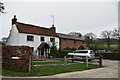
1
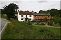
Wharf Cottages
Wharf Cottages were situated at the limit of the now disused River Ouse Navigation. It would have been a very busy place when the 11 million bricks arrived for the construction of the adjacent Balcombe Viaduct.
Image: © Peter Jeffery
Taken: 1 Oct 2005
0.00 miles
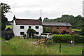
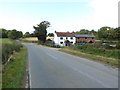
5

Wharf Cottages, Borde Hill Lane
The white cottage on the left is the older of the two dating back to the 18th century with the brick fronted cottage added in the 19th. The cottages face out onto the former wharf the northern terminus of the River Ouse navigation that ended at Upper Ryelands Bridge. Borde Hill Lane is an old highway that links Haywards Heath to Balcombe.
Image: © Simon Carey
Taken: 18 Apr 2015
0.01 miles
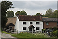
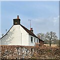
6
Wharf Cottages on Bordehill Lane
See also http://www.geograph.org.uk/photo/3674432 from 2005.
Image: © Shazz
Taken: 12 Oct 2016
0.01 miles
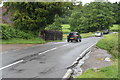
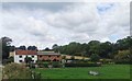
10
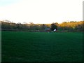
Field Number 411 (2)
The number of the field according to Balcombe's 1839 tithe map that had been taken out of agricultural use and marked as 'Part of the Rial Road'. The field would have been home between 1839 and 1841 to the shanty town of the navvies and the storage area for the materials to build the viaduct. The bricks would have been landed at the wharf next to Upper Ryelands Bridge on the River Ouse Navigation, the area beyond the hedge on the right hand side of the image. The building obscured by the tree is Wharf Cottages. See also Image
Image: © Simon Carey
Taken: 18 Apr 2015
0.03 miles