IMAGES TAKEN NEAR TO
Stockcroft Road, HAYWARDS HEATH, RH17 6LQ
Introduction
This page details the photographs taken nearby to Stockcroft Road, RH17 6LQ by members of the Geograph project.
The Geograph project started in 2005 with the aim of publishing, organising and preserving representative images for every square kilometre of Great Britain, Ireland and the Isle of Man.

There are currently over 7.5m images from over14,400 individuals and you can help contribute to the project by visiting https://www.geograph.org.uk
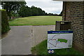
Image Map
Images are licensed for reuse under creativecommons.org/licenses/by-sa/2.0
Notes
- Clicking on the map will re-center to the selected point.
- The higher the marker number, the further away the image location is from the centre of the postcode.
Image Listing (171 Images Found)
Images are licensed for reuse under creativecommons.org/licenses/by-sa/2.0
Image
Details
Distance
1
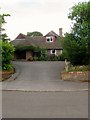
Beechcroft, Stockcroft Road, Balcombe
Built in the first decade of the 20th century and for many years was known as tower House and was home to the Rapha House Surgery. Part of the grounds were given over to Image at the end of the 1970s whilst the surgery itself was converted into a residence around 2000.
Image: © Simon Carey
Taken: 25 Jul 2015
0.00 miles
2
Merrow House, Stockcroft Road, Balcombe
A former large house built in the first decade of the 20th century now converted into flats to the rear of which is Image
Image: © Simon Carey
Taken: 25 Jul 2015
0.02 miles
3
Merrow Cottage, Stockcroft Road, Balcombe
A former outbuilding in the grounds of Merrow House that has been converted into a cottage that overlooks the recreation ground.
Image: © Simon Carey
Taken: 18 Jul 2015
0.02 miles
4
Balcombe Telephone Exchange, Stockcroft Road, Balcombe
Built in the late 1970s in the grounds of Tower House that is now known as Image
Image: © Simon Carey
Taken: 25 Jul 2015
0.02 miles
5
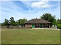
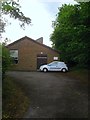
Pavilion, Balcombe Recreation Ground
Owned by the parish council and used by local football teams and a youth club.
Image: © Simon Carey
Taken: 18 Jul 2015
0.03 miles
8
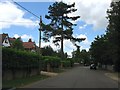
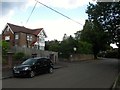
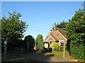
Stockcroft Road, Balcombe
A residential road that runs from Bramble Hill to Oldlands Road which was laid out in the first decade of the 20th century to cater for the growing number of commuters moving into the village. The buildings on the left are Avon House and Orchard House respectively.
Image: © Simon Carey
Taken: 27 Jun 2015
0.04 miles
9
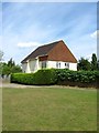
The Parish Room, Stockcroft Road, Balcombe
Balcombe is well stocked for rooms and places to hire; Image and Image being two alternatives to this one that is located between the village bowls club and an indoor rifle range. One of its main occupants is Tiggers, a preschool nursery.
Image: © Simon Carey
Taken: 18 Jul 2015
0.05 miles
10
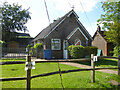
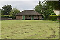
Balcombe Parish Room
One of a surprising number of Balcombe community buildings, currently the home of Tiggers Preschool.
Image: © Robin Webster
Taken: 8 Jun 2021
0.05 miles