IMAGES TAKEN NEAR TO
Brantridge Lane, HAYWARDS HEATH, RH17 6JS
Introduction
This page details the photographs taken nearby to Brantridge Lane, RH17 6JS by members of the Geograph project.
The Geograph project started in 2005 with the aim of publishing, organising and preserving representative images for every square kilometre of Great Britain, Ireland and the Isle of Man.

There are currently over 7.5m images from over14,400 individuals and you can help contribute to the project by visiting https://www.geograph.org.uk
Image Map
Images are licensed for reuse under creativecommons.org/licenses/by-sa/2.0
Notes
- Clicking on the map will re-center to the selected point.
- The higher the marker number, the further away the image location is from the centre of the postcode.
Image Listing (32 Images Found)
Images are licensed for reuse under creativecommons.org/licenses/by-sa/2.0
Image
Details
Distance
1
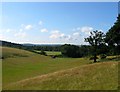
Hollow Field/Great Lion
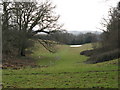
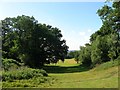
The name of the fields according to Cuckfield's 1843 tithe map. Hollow Field is indeed in the hollow in the foreground merged with Image to its north. Just visible to the south is Great Lion which is bounded by Long Wood to its south, Seyron Wood to the east and Image to its north. Viewed from the plateau above containing Image The ridge in the distance contains Whitemans Green, now a northern suburb of Cuckfield.
Image: © Simon Carey
Taken: 25 Jul 2015
0.12 miles
2
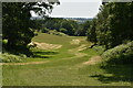
Flat Field/Middle Four Acres
The name of the fields according to Cuckfield's 1843 tithe map that have been merged to form a larger unit. Flat Field is in the foreground whilst Middle Four Acres is further to the south. To the west is Image, to the north is Image whilst to the east is Image The ridge visible in the distance contains Whitemans Green.
Image: © Simon Carey
Taken: 25 Jul 2015
0.17 miles
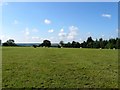
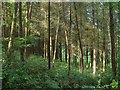
5
Field and murky view
Looking south over The Weald
Image: © Dave Spicer
Taken: 24 Jan 2009
0.18 miles
7
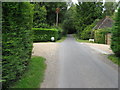
Road mirror for Washlands on Brantridge Lane
Image: © Dave Spicer
Taken: 30 Aug 2009
0.18 miles
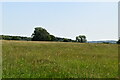
8
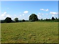
Bellows Nose
The name of the field according to Cuckfield's 1843 tithe map that is found on a small plateau which then drops down into Image to the south. To the west is Image, to the east is Image whilst to the north is Image The name derives from the field's triangular shape.
Image: © Simon Carey
Taken: 25 Jul 2015
0.18 miles
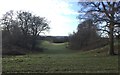
9
Hollow Mead
The name of the field according to Cuckfield's 1843 tithe map which lies in a hollow between Image to the east and Image to the north and west. The field has been merged with Hollow Field to the south, see Image
Image: © Simon Carey
Taken: 25 Jul 2015
0.19 miles
10
Poor Field
The name of the field according to Cuckfield's 1843 tithe map that had become a plantation by the 1874-75 OS map. Its name suggesting its unsuitability for agricultural uses. It is located to the west of Image
Image: © Simon Carey
Taken: 25 Jul 2015
0.20 miles