IMAGES TAKEN NEAR TO
Tanyard Lane, HAYWARDS HEATH, RH17 6HJ
Introduction
This page details the photographs taken nearby to Tanyard Lane, RH17 6HJ by members of the Geograph project.
The Geograph project started in 2005 with the aim of publishing, organising and preserving representative images for every square kilometre of Great Britain, Ireland and the Isle of Man.

There are currently over 7.5m images from over14,400 individuals and you can help contribute to the project by visiting https://www.geograph.org.uk
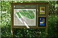
Image Map
Images are licensed for reuse under creativecommons.org/licenses/by-sa/2.0
Notes
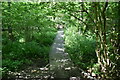
- Clicking on the map will re-center to the selected point.
- The higher the marker number, the further away the image location is from the centre of the postcode.
Image Listing (48 Images Found)
Images are licensed for reuse under creativecommons.org/licenses/by-sa/2.0
Image
Details
Distance
1
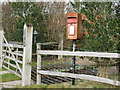
Private mail box
Mail box at entrance to Old House Image
Image: © Dave Spicer
Taken: 24 Jan 2009
0.02 miles

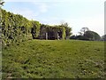
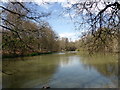
5
Lake at bottom of garden
The lawn, right of centre, belongs to Old House Image
Image: © Dave Spicer
Taken: 24 Jan 2009
0.06 miles
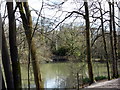
9
An Ancient Highway
This was once a busy thoroughfare carrying heavy traffic to and from the nearby ironworks,which were powered by the Hammer Ponds in the valley to the left of the picture.
Image: © Peter Jeffery
Taken: 1 Jun 2012
0.08 miles
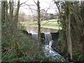
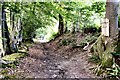
10
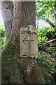
London This Way
An unexpected sign on a country walk. The track once led to one of many sites of the Sussex Iron Industry.
Image: © Peter Jeffery
Taken: 1 Jun 2012
0.08 miles