IMAGES TAKEN NEAR TO
Buckingham Gate, HAYWARDS HEATH, RH17 6FP
Introduction
This page details the photographs taken nearby to Buckingham Gate, RH17 6FP by members of the Geograph project.
The Geograph project started in 2005 with the aim of publishing, organising and preserving representative images for every square kilometre of Great Britain, Ireland and the Isle of Man.

There are currently over 7.5m images from over14,400 individuals and you can help contribute to the project by visiting https://www.geograph.org.uk
Image Map
Images are licensed for reuse under creativecommons.org/licenses/by-sa/2.0
Notes
- Clicking on the map will re-center to the selected point.
- The higher the marker number, the further away the image location is from the centre of the postcode.
Image Listing (41 Images Found)
Images are licensed for reuse under creativecommons.org/licenses/by-sa/2.0
Image
Details
Distance
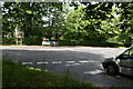
1
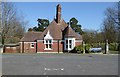
Handcross Park School Gatehouse, Handcross, West Sussex
The other school in Handcross, and just over the road from the county council run Primary (see picture). This is a privately run preparatory school for girls and boys up to the age of 13. The picture shows the gate lodge at the main entrance to the mansion and 50 acres of school grounds. View taken from the B2115 looking E.
Image: © Pete Chapman
Taken: 28 Jul 2005
0.07 miles
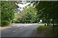
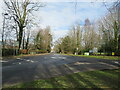
2
Looking south on the A23 to the Handcross turn off
Image: © Shazz
Taken: 25 Mar 2016
0.09 miles
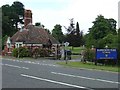
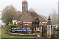
3
West Lodge opposite Hoadlands
A different view is at http://www.geograph.org.uk/photo/4728881.
Image: © Shazz
Taken: 25 Mar 2016
0.11 miles
4
Entrance to Handcross Park School, Handcross, West Sussex
Image: © Christine Matthews
Taken: 1 Nov 2015
0.11 miles
5
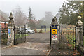
Entrance to Handcross Park School, Handcross, West Sussex
Image: © Christine Matthews
Taken: 1 Nov 2015
0.11 miles
6
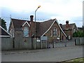
Handcross Primary School, Handcross, West Sussex
To the N of the village. At one time blighted by the adjacent A23 dual carriageway. The A23 was diverted to bypass the school and now follows a route 200m behind it. A traditional design of village school building. Run by West Sussex County Council.
Image: © Pete Chapman
Taken: 28 Jul 2005
0.11 miles
7
Roundabout, Handcross
This is the junction of the B2110 (from Turners Hill) with the B2114 from Pease Pottage to Handcross.
Image: © Richard Rogerson
Taken: 9 Mar 2024
0.12 miles
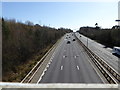
8
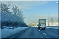
A23 northbound
The bridge is private access to Hoadlands Farm.
Image: © Robin Webster
Taken: 7 Jan 2010
0.12 miles