IMAGES TAKEN NEAR TO
Mallions Lane, HAYWARDS HEATH, RH17 6AT
Introduction
This page details the photographs taken nearby to Mallions Lane, RH17 6AT by members of the Geograph project.
The Geograph project started in 2005 with the aim of publishing, organising and preserving representative images for every square kilometre of Great Britain, Ireland and the Isle of Man.

There are currently over 7.5m images from over14,400 individuals and you can help contribute to the project by visiting https://www.geograph.org.uk
Image Map
Images are licensed for reuse under creativecommons.org/licenses/by-sa/2.0
Notes
- Clicking on the map will re-center to the selected point.
- The higher the marker number, the further away the image location is from the centre of the postcode.
Image Listing (7 Images Found)
Images are licensed for reuse under creativecommons.org/licenses/by-sa/2.0
Image
Details
Distance
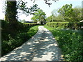
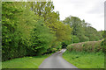
3
Mallion's Lane
Southwards towards the B2115.
Image: © Robin Webster
Taken: 16 May 2010
0.14 miles
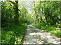
4
An Autumnal View of Mallions Lane, West Sussex
A narrow and little used minor country lane. The leaves are little disturbed by passing traffic, which produces two parallel tyre tracks. View taken looking E on a sharp right hand (if travelling from the N) bend. See Mallion's lane N end in Image
Image: © Pete Chapman
Taken: 21 Oct 2005
0.21 miles
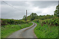
6
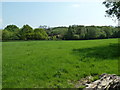
View across field to house on Mallion's Lane
Taken from Staplefield Road.
Image: © Dave Spicer
Taken: 23 Apr 2011
0.22 miles
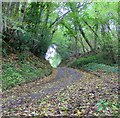
7
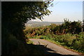
Mallion's Lane
With Staplefeild in the distance
Image: © Peter Jeffery
Taken: 1 Nov 2006
0.23 miles