IMAGES TAKEN NEAR TO
Coos Lane, HAYWARDS HEATH, RH17 6AD
Introduction
This page details the photographs taken nearby to Coos Lane, RH17 6AD by members of the Geograph project.
The Geograph project started in 2005 with the aim of publishing, organising and preserving representative images for every square kilometre of Great Britain, Ireland and the Isle of Man.

There are currently over 7.5m images from over14,400 individuals and you can help contribute to the project by visiting https://www.geograph.org.uk
Image Map
Images are licensed for reuse under creativecommons.org/licenses/by-sa/2.0
Notes
- Clicking on the map will re-center to the selected point.
- The higher the marker number, the further away the image location is from the centre of the postcode.
Image Listing (4 Images Found)
Images are licensed for reuse under creativecommons.org/licenses/by-sa/2.0
Image
Details
Distance
1
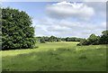
Fields on the trail
Leaving Slaugham on the High Weald Landscape Trail.
Image: © Chris Thomas-Atkin
Taken: 24 May 2020
0.09 miles
2
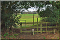
Stile off Coos Lane
The footpath is to Horsham Road.
Image: © Robin Webster
Taken: 5 Apr 2010
0.10 miles
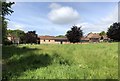
3

Wealden landscape near Slaugham
The countryside hereabouts is a mixture of wooded hills and flat grassland. Taken from the High Weald Landscape Trail.
Image: © David Kemp
Taken: 16 May 2013
0.14 miles
4
Field beside Ashfold Farm
Passing by the farm on the High Weald Landscape Trail.
Image: © Chris Thomas-Atkin
Taken: 24 May 2020
0.23 miles