IMAGES TAKEN NEAR TO
Cowfold Road, HAYWARDS HEATH, RH17 5QX
Introduction
This page details the photographs taken nearby to Cowfold Road, RH17 5QX by members of the Geograph project.
The Geograph project started in 2005 with the aim of publishing, organising and preserving representative images for every square kilometre of Great Britain, Ireland and the Isle of Man.

There are currently over 7.5m images from over14,400 individuals and you can help contribute to the project by visiting https://www.geograph.org.uk
Image Map
Images are licensed for reuse under creativecommons.org/licenses/by-sa/2.0
Notes
- Clicking on the map will re-center to the selected point.
- The higher the marker number, the further away the image location is from the centre of the postcode.
Image Listing (34 Images Found)
Images are licensed for reuse under creativecommons.org/licenses/by-sa/2.0
Image
Details
Distance
1
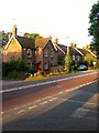
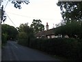
Diamond Cottages, Cowfold Road, Crosspost
A set of three semi-detached cottages built in 1897 on the western side of the crossroads.
Image: © Simon Carey
Taken: 25 Sep 2014
0.00 miles
2
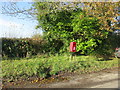
Post Box
RH17 58 Crosspost (Haywards Heath)
Image: © The Saunterer
Taken: 25 Nov 2012
0.02 miles
3
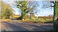
Crosspost junction
Foxhole Road meets Cowfold Road (A272)
Image: © The Saunterer
Taken: 25 Nov 2012
0.02 miles
4
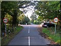
Site of Crosspost Gate, Crosspost
A former tollhouse was built on the right hand side of the crossroads in 1825 occupying the site where the cars are now parked. It was decommissioned in the 1880s but survived as a residence until 1962 when it was demolished. Foxhole Lane is in the foreground whilst beyond the A272 is Bolney Chapel Road. The gate on the left leads to Image whilst part of Image can be seen on the right.
Image: © Simon Carey
Taken: 25 Sep 2014
0.02 miles
5
Crosspost Cottage, Bolney Chapel Road, Crosspost
Located to the immediate south of the former chapel and dating from at least the 19th century. The crossroads at Crosspost can be seen beyond.
Image: © Simon Carey
Taken: 19 Sep 2014
0.03 miles
6
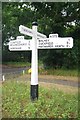
Direction Sign - Signpost by the A272 at Crosspost, Bolney
Black iron cap finial - 4 arms; East Sussex wood with number by the A272, in parish of Bolney (Mid Sussex District), Cowfold Road (Hamlet at this crossroads is known as "Crosspost"). On grass verge at crossroads where Bolney Chapel Road and Foxhole Lane intersect with the A272.
Lost after April 2021.
Surveyed
Milestone Society National ID: SX_TQ2522
Image: © Milestone Society
Taken: Unknown
0.03 miles
7
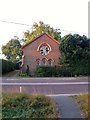
Bolney Providence Chapel, Cowfold Road, Crosspost
There has been a non-conformist chapel at Crosspost since 1765 though the current one dates from 1858. It closed in 1971, was de-sanctified in 1984 and converted into a home. The former graveyard still sexists in what is now the private dwelling's garden.
Image: © Simon Carey
Taken: 25 Sep 2014
0.04 miles
8
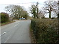
Crossroads at Crosspost
Crosspost may have derived its name from the crossroads.
Image: © Dave Spicer
Taken: 6 Mar 2011
0.04 miles
9
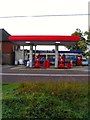
Crosspost Service Station, Cowfold Road, Crosspost
There has been a garage here since the interwar years and still survives today with a small village shop inside. It is located between Image to the east and Image to the west.
Image: © Simon Carey
Taken: 25 Sep 2014
0.05 miles