IMAGES TAKEN NEAR TO
London Road, HAYWARDS HEATH, RH17 5QF
Introduction
This page details the photographs taken nearby to London Road, RH17 5QF by members of the Geograph project.
The Geograph project started in 2005 with the aim of publishing, organising and preserving representative images for every square kilometre of Great Britain, Ireland and the Isle of Man.

There are currently over 7.5m images from over14,400 individuals and you can help contribute to the project by visiting https://www.geograph.org.uk
Image Map
Images are licensed for reuse under creativecommons.org/licenses/by-sa/2.0
Notes
- Clicking on the map will re-center to the selected point.
- The higher the marker number, the further away the image location is from the centre of the postcode.
Image Listing (15 Images Found)
Images are licensed for reuse under creativecommons.org/licenses/by-sa/2.0
Image
Details
Distance
1
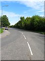
London Road
The old course of the A23 heading north from Image to eventually join the new course near Beggars Bush Cottage, see Image
Image: © Simon Carey
Taken: 25 Sep 2014
0.05 miles
3
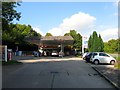
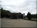
Jeremy's Corner Service Station
Located at the junction of London Road and Jeremy's Lane, there has been a filling station here since the end of the Second World War and whilst originally on the main A23 it has retained a slip road since the rerouting of the road in the early 1990s.
Image: © Simon Carey
Taken: 19 Sep 2014
0.07 miles

7
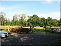
Great Stroods
The name of the field according to Bolney's 1842 tithe map that is now a series of paddocks and lies between Jermey's lane to the west and London Road to the east.
Image: © Simon Carey
Taken: 19 Sep 2014
0.09 miles
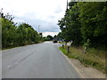
9
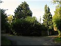
Jeremy's Lane
A narrow country lane that runs between London Road, the former A23, and Colwood Lane. This bend lies at its eastern end and was the original eastern junction for the lane as an old north lane ran from Cuckfield Lane, now the B2115, west of Pitts Head Crossroads and headed south via Hazelden Farm, Beggars Bush Bottom and Hill House Farm to this point here. In the early 19th century a portion of the lane became the London-Brighton turnpike though it seems to have been rerouted by the 1842 tithe map and the old lane stopped up with just the southern portion becoming part of Jeremy's Lane the section beyond the old junction the drive to Hill House Farm. To the north the old lane can still be made out in places by field boundaries.
Image: © Simon Carey
Taken: 19 Sep 2014
0.13 miles
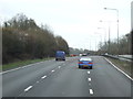
10
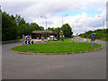
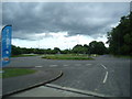
Garage north of Bolney
The roundabout marks the junction with the old A23 and Jeremy's Lane.
Image: © Simon Carey
Taken: 26 Aug 2006
0.13 miles