IMAGES TAKEN NEAR TO
Foxhole Lane, HAYWARDS HEATH, RH17 5NB
Introduction
This page details the photographs taken nearby to Foxhole Lane, RH17 5NB by members of the Geograph project.
The Geograph project started in 2005 with the aim of publishing, organising and preserving representative images for every square kilometre of Great Britain, Ireland and the Isle of Man.

There are currently over 7.5m images from over14,400 individuals and you can help contribute to the project by visiting https://www.geograph.org.uk
Image Map
Images are licensed for reuse under creativecommons.org/licenses/by-sa/2.0
Notes
- Clicking on the map will re-center to the selected point.
- The higher the marker number, the further away the image location is from the centre of the postcode.
Image Listing (35 Images Found)
Images are licensed for reuse under creativecommons.org/licenses/by-sa/2.0
Image
Details
Distance
1
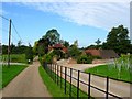
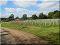
Booker's Vineyard
The name of the house that was the original name of the vineyard opened in 1972 with three acres which has now expanded to thirty nine producing quality red wine. Now called Bolney Wine Estate the premises is open to the public for tasting and tours and includes a cafe and since march 2014 the village post office. The drive on the left leads to Image whilst the fields either side of the two drives in the foreground are Image to the left and Image to the right.
Image: © Simon Carey
Taken: 31 Aug 2014
0.01 miles
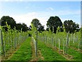
2
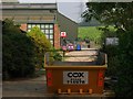
Bolney Wine Estate
The main public buildings for the vineyard includes a cafe and since March 2014 the village post office. The field beyond is Image
Image: © Simon Carey
Taken: 7 Sep 2014
0.03 miles
4
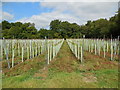
Barn Field
The name of the field according to Bolney's 1842 tithe map that is bounded by Image to the south, Image to the east, Image to the north and Image to the west. Now part of Bolney Wine Estate
Image: © Simon Carey
Taken: 31 Aug 2014
0.05 miles
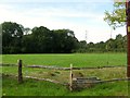
6
Little Mead
The name of the field according to Bolney's 1842 tithe map that is bounded by Image to the east, Image to the west and Image to the north. Now part of Bolney Wine Estate.
Image: © Simon Carey
Taken: 31 Aug 2014
0.05 miles
7
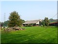
Barns, Bolney Wine Estate
To the rear of the main public building for the Bolney Wine Estate and looking up a footpath that heads west to Old Mill Farm. Out of shot to the left is Image
Image: © Simon Carey
Taken: 7 Sep 2014
0.06 miles
8
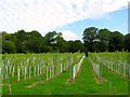
Cow Field
The name of the field according to Bolney's 1842 tithe map that lies to the east of Image and west of Image
Image: © Simon Carey
Taken: 31 Aug 2014
0.06 miles
9
Booker's Barn
Converted barn that lies to the immediate east of Image which lies just out of shot to the left.
Image: © Simon Carey
Taken: 7 Sep 2014
0.07 miles
10
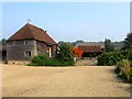
Booker's Farm
The farmhouse on the right dates from the 17th century whilst the barn to the left is even older dating back to the 15th century.
Image: © Simon Carey
Taken: 31 Aug 2014
0.07 miles