IMAGES TAKEN NEAR TO
Ledgers Meadow, HAYWARDS HEATH, RH17 5EW
Introduction
This page details the photographs taken nearby to Ledgers Meadow, RH17 5EW by members of the Geograph project.
The Geograph project started in 2005 with the aim of publishing, organising and preserving representative images for every square kilometre of Great Britain, Ireland and the Isle of Man.

There are currently over 7.5m images from over14,400 individuals and you can help contribute to the project by visiting https://www.geograph.org.uk
Image Map
Images are licensed for reuse under creativecommons.org/licenses/by-sa/2.0
Notes
- Clicking on the map will re-center to the selected point.
- The higher the marker number, the further away the image location is from the centre of the postcode.
Image Listing (117 Images Found)
Images are licensed for reuse under creativecommons.org/licenses/by-sa/2.0
Image
Details
Distance
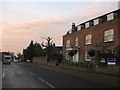
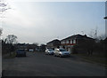
1
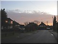
Ledgers Meadow, Cuckfield
Small cul de sac built in the 1950s off the High Street. Taken at sunrise.
Image: © Simon Carey
Taken: 29 Nov 2014
0.01 miles
2
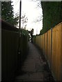
Mytten Twitten, Cuckfield
A narrow alley that runs from the High Street to London Lane. Marked as Mytten Lane on all OS maps up to 1938 acquiring its current name by the 1956 edition. This section looks down towards Mytten Close after which it swings west towards the High Street.
Image: © Simon Carey
Taken: 20 Dec 2014
0.05 miles
3
Vine Cottage North/Vine Cottage South, High Street, Cuckfield
The cottages date back to the 16th century but were refronted in the 1920s.
Image: © Simon Carey
Taken: 29 Nov 2014
0.06 miles
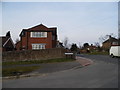
4
Northern Breach, High Street, Cuckfield
A set of houses built in the 1960s on the site of a former single house of the same name. Numbers 1-4 are in view with detached house to the right being Lunces.
Image: © Simon Carey
Taken: 6 Dec 2014
0.06 miles
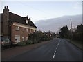
5
Cuckfield House, High Street, Cuckfield
Large 19th century house towards the northern end of the High Street originally known as Banks.
Image: © Simon Carey
Taken: 29 Nov 2014
0.06 miles
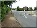
6
Leyton Lea at the junction of Cuckfield High Street
Image: © David Howard
Taken: 7 Apr 2013
0.06 miles
7
Little Ledgers, Cuckfield
A small cul de sac containing four dwellings off London Lane built in 1997.
Image: © Simon Carey
Taken: 20 Dec 2014
0.06 miles
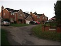
8
Mytten Close, Cuckfield
This is a western extension of the cul de sac added in the mid 1970s in the former grounds of Mytten House which still exists behind the fence to the left.
Image: © Simon Carey
Taken: 20 Dec 2014
0.07 miles
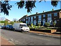
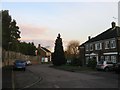
9
Leyton Lea, Cuckfield
A typical neo-Georgian estate from the 1970-80s
Image: © David Howard
Taken: 7 Apr 2013
0.07 miles
10
New residential road off the High Street
The road to the right is Ashburnham Drive a fairly new housing area not shown on Google aerial shot.
Image: © Dave Spicer
Taken: 10 Jul 2011
0.07 miles