IMAGES TAKEN NEAR TO
Hatchgate Close, HAYWARDS HEATH, RH17 5DT
Introduction
This page details the photographs taken nearby to Hatchgate Close, RH17 5DT by members of the Geograph project.
The Geograph project started in 2005 with the aim of publishing, organising and preserving representative images for every square kilometre of Great Britain, Ireland and the Isle of Man.

There are currently over 7.5m images from over14,400 individuals and you can help contribute to the project by visiting https://www.geograph.org.uk
Image Map
Images are licensed for reuse under creativecommons.org/licenses/by-sa/2.0
Notes
- Clicking on the map will re-center to the selected point.
- The higher the marker number, the further away the image location is from the centre of the postcode.
Image Listing (29 Images Found)
Images are licensed for reuse under creativecommons.org/licenses/by-sa/2.0
Image
Details
Distance
1
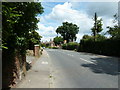
NW on Broad Street Cuckfield
Broad Street is the B2184 linking the B2036 with the A272 Cuckfield by-pass. If my memory is correct this was the A272 before the by-pass.
Image: © Dave Spicer
Taken: 10 Jul 2011
0.02 miles
2
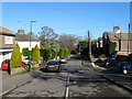
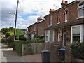
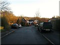
Hatchgate Lane, Cuckfield
The old medieval route to Lindfield is now a cul de sac at the eastern end of Cuckfield. Marked as a Whapple Way on a 1638 estate map it is now little more than a bridleway beyond Hatchgate Farm with much of there set of the route lying beneath the Harlands estate in Haywards Heath. The houses on the right date from the last quarter of the 19th century.
Image: © Simon Carey
Taken: 17 Feb 2015
0.04 miles
3
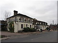
The Mount/Hill Bank, Broad Street, Cuckfield
The semi-detached houses on the left were built during the Edwardian era with this section of Cuckfield developed from the last quarter of the 19th century onwards.
Image: © Simon Carey
Taken: 17 Feb 2015
0.05 miles
6
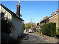
Horsgate Lane, Cuckfield
Originally the access road for Horsgate Farm and from the 1860s Cuckfield Gas Works which now lies beneath Image Halcyon Cottage on the left dates from the late 19th century and was the first house to be developed whilst Albany Villas to the right were added during the Edwardian period.
Image: © Simon Carey
Taken: 17 Feb 2015
0.11 miles
7
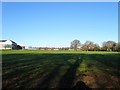
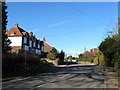
Playing Fields, Warden Park School, Cuckfield
This set of fields are located to the east of the school buildings and encompass two former fields called Upper Ten Acres and Windmill Field, the former being in the foreground the latter in the distance adjacent to Broad Street. Prior to being enclosed fields this was the eastern end of Cuckfield's medieval deer park which was disparked in the 16th century.
Image: © Simon Carey
Taken: 13 Dec 2014
0.14 miles
8
Chatfield Road, Cuckfield
A residential road that links London Lane to Horsgate Lane that was developed just before the First World War with later infilling.
Image: © Simon Carey
Taken: 17 Feb 2015
0.15 miles
9
The Brambles, Cuckfield
A cul de sac off Image that was built in the 1990s on the old site of Cuckfield gas works.
Image: © Simon Carey
Taken: 17 Feb 2015
0.16 miles
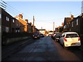
10
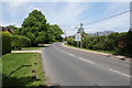
Broad Street, Cuckfield
Heading towards the centre of Cuckfield. Behind the hedge to the right is some more greenfield housing development. Established houses are to the left.
Image: © Bill Boaden
Taken: 11 May 2018
0.16 miles