IMAGES TAKEN NEAR TO
Bolney Road, HAYWARDS HEATH, RH17 5AN
Introduction
This page details the photographs taken nearby to Bolney Road, RH17 5AN by members of the Geograph project.
The Geograph project started in 2005 with the aim of publishing, organising and preserving representative images for every square kilometre of Great Britain, Ireland and the Isle of Man.

There are currently over 7.5m images from over14,400 individuals and you can help contribute to the project by visiting https://www.geograph.org.uk
Image Map
Images are licensed for reuse under creativecommons.org/licenses/by-sa/2.0
Notes
- Clicking on the map will re-center to the selected point.
- The higher the marker number, the further away the image location is from the centre of the postcode.
Image Listing (62 Images Found)
Images are licensed for reuse under creativecommons.org/licenses/by-sa/2.0
Image
Details
Distance
1
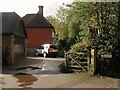
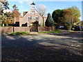
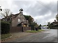
The Ancient Farm, Bolney Road, Ansty
Located at the village crossroads and believed to date back to the 15th century. Up to the Second World War it was known as Crouchfields or Crouchlands Farm.
Image: © Simon Carey
Taken: 11 Oct 2014
0.01 miles
2
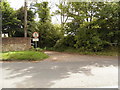
Minor road joining the A272, Ansty, West Sussex
Image: © nick macneill
Taken: 12 Aug 2011
0.01 miles
3
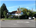
The Old Cottage, Cuckfield Road, Ansty
Located at the junction of the A272 and B2035 and dating back to the 16th century.
Image: © Simon Carey
Taken: 5 Oct 2014
0.02 miles
4
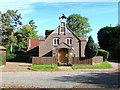
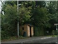
St John's, Deaks Lane, Ansty
Opened in 1883 as a mission room later becoming a chapel until its closure in 2001. Now a private residence.
Image: © Simon Carey
Taken: 5 Oct 2014
0.03 miles
5
"St John's" on Deak's Lane
See http://www.geograph.org.uk/photo/4195839 from 2014 for more information.
Image: © Shazz
Taken: 6 Nov 2016
0.03 miles
6
Ansty Cross mini roundabout
There is a public house at this location called the Ansty Cross and a garage also selling motors.
Image: © Nigel Freeman
Taken: 2 Jul 2005
0.03 miles
8
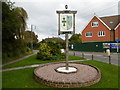
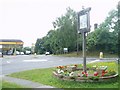
The village sign at Ansty
Some relatively recent maps spell Ansty with an 'e' on the end.
Image: © Marathon
Taken: 10 Oct 2015
0.03 miles
9
St John?s Church
The Church in Ansty.
Image: © Chris Thomas-Atkin
Taken: 28 Oct 2018
0.03 miles
10
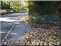
Looking westwards on Bolney Road
There is a commemorative bench in the foreground.
Image: © Shazz
Taken: 6 Nov 2016
0.03 miles