IMAGES TAKEN NEAR TO
Cuckfield Road, HAYWARDS HEATH, RH17 5AF
Introduction
This page details the photographs taken nearby to Cuckfield Road, RH17 5AF by members of the Geograph project.
The Geograph project started in 2005 with the aim of publishing, organising and preserving representative images for every square kilometre of Great Britain, Ireland and the Isle of Man.

There are currently over 7.5m images from over14,400 individuals and you can help contribute to the project by visiting https://www.geograph.org.uk
Image Map
Images are licensed for reuse under creativecommons.org/licenses/by-sa/2.0
Notes
- Clicking on the map will re-center to the selected point.
- The higher the marker number, the further away the image location is from the centre of the postcode.
Image Listing (58 Images Found)
Images are licensed for reuse under creativecommons.org/licenses/by-sa/2.0
Image
Details
Distance
1
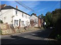
The Old Shop, Cuckfield Road, Ansty
To the immediate north of Image with Westhill Villas beyond. Not sure when it closed but it had served the village for over 100 years.
Image: © Simon Carey
Taken: 5 Oct 2014
0.01 miles
2

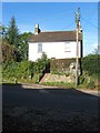
The Lizard, Cuckfield Road, Ansty
The name of the bungalow that lies on the corner of the A272 and the drive to Ansty Farm. It looks like the southern end adjacent to the drive seems to be the oldest part of the dwelling dating back to the 19th century with the northern part added as a 20th century extension. It may have originally been a lodge for Ansty Farm. Its neighbour to the south was once Image which is now awaiting development.
Image: © Simon Carey
Taken: 11 Oct 2014
0.03 miles
3
Rock Cottages, Cuckfield Road, Ansty
Built in 1861 and located just to the south of the main road junction in the village on the road to Cuckfield. Its neighbour to the north is Image
Image: © Simon Carey
Taken: 5 Oct 2014
0.03 miles
4
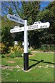
Old Direction Sign - Signpost by the A272, Bolney Road, Ansty and Staplefield
Black iron cap finial - 3 arms; East Sussex wood with number by the A272, in parish of Ansty and Staplefield (Mid Sussex District), A272 at Ansty, on verge opposite junction with B2036 - Pains Flat with A272.
Surveyed
Milestone Society National ID: SX_TQ2923
Image: © Milestone Society
Taken: Unknown
0.04 miles
5
Ansty Cross Inn (Demolished)
The former pub had a precarious existence during the 1990s having closed then reopened due to lack of patronage before succumbing again in 2011 this time for good as the building was demolished in November 2014. The developers have agreed to place the distinctive green cross that fronted the former pub on any new building as a memorial.
See Image for when open, and Image after closure and pre-demolition.
Image: © Simon Carey
Taken: 30 Dec 2014
0.04 miles
6
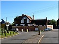
Ansty Cross Inn, Cuckfield Road, Ansty
For many years the Green Cross Inn before becoming the Ansty Cross, the old name of the village built around a crossroads. The pub shut in the late 1990s but reopened but has been closed since 2011 due to lack of patronage. The fencing around the premises suggests redevelopment is imminent.
Image: © Simon Carey
Taken: 5 Oct 2014
0.04 miles
7
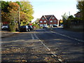
Houses at the mini roundabout in Ansty
The road is the A272. See http://www.geograph.org.uk/photo/4297403 for information on the history of this site. Both houses sport a green cross.
Image: © Shazz
Taken: 6 Nov 2016
0.04 miles
8

Ansty Village Sign
Located at the crossroads which the village is built around. The current sign was commissioned by the local council in 2011 to replace an older one which had faded badly painted by dramatist James Forsyth in the 1970s who lived in the village until his death in 2005. The original frame remains whilst the design includes the green cross of the local landowning family who resided at Legh Manor whilst the road represents the highway the village was built around and the hart for its location next to the former Cuckfield deer park. Beyond is Image
Image: © Simon Carey
Taken: 11 Oct 2014
0.04 miles
10
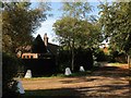
Birch Trees Farm, Webbers Lane, Ansty
The whitewashed former dragons teeth from World War Two mark the entrance to a caravan club only camping site. Webbers Lane seems to be a local name given to the track that provides access to Ansty Farm.
Image: © Simon Carey
Taken: 5 Oct 2014
0.05 miles