IMAGES TAKEN NEAR TO
Oaklands Drive, REDHILL, RH1 6RX
Introduction
This page details the photographs taken nearby to Oaklands Drive, RH1 6RX by members of the Geograph project.
The Geograph project started in 2005 with the aim of publishing, organising and preserving representative images for every square kilometre of Great Britain, Ireland and the Isle of Man.

There are currently over 7.5m images from over14,400 individuals and you can help contribute to the project by visiting https://www.geograph.org.uk
Image Map
Images are licensed for reuse under creativecommons.org/licenses/by-sa/2.0
Notes
- Clicking on the map will re-center to the selected point.
- The higher the marker number, the further away the image location is from the centre of the postcode.
Image Listing (10 Images Found)
Images are licensed for reuse under creativecommons.org/licenses/by-sa/2.0
Image
Details
Distance
2
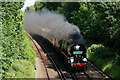
'Clan Line'
No.35028 'Clan Line', approaching Redhill with a circular tour from Victoria via Dover Priory.
Image: © Peter Trimming
Taken: 11 Jun 2022
0.13 miles
3
Lane to the lake
The extension of Eastfield Lane.
Image: © N Chadwick
Taken: 23 Jan 2011
0.18 miles
4
Eastfield Road - the really private bit
Eastfield Road does not appear on Surrey County Council's map of maintained roads, so presumably it is private from its start off Philanthropic Road. However, it does not say so until just behind this point.
Image: © Robin Webster
Taken: 14 Jul 2010
0.19 miles
5

Houses on Hawthorn Way
Some looking empty. Built as part of the former approved school here, presumably they were staff houses.
Image: © Robin Webster
Taken: 14 Jul 2010
0.20 miles


10
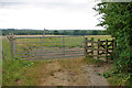
Gates by site of Old Garston's House
The footpath gate is used by the Greensand Way long distance path which heads round to the right.
Image: © Robin Webster
Taken: 14 Jul 2010
0.25 miles