IMAGES TAKEN NEAR TO
Carters Cottages, REDHILL, RH1 6QQ
Introduction
This page details the photographs taken nearby to Carters Cottages, RH1 6QQ by members of the Geograph project.
The Geograph project started in 2005 with the aim of publishing, organising and preserving representative images for every square kilometre of Great Britain, Ireland and the Isle of Man.

There are currently over 7.5m images from over14,400 individuals and you can help contribute to the project by visiting https://www.geograph.org.uk
Image Map
Images are licensed for reuse under creativecommons.org/licenses/by-sa/2.0
Notes
- Clicking on the map will re-center to the selected point.
- The higher the marker number, the further away the image location is from the centre of the postcode.
Image Listing (114 Images Found)
Images are licensed for reuse under creativecommons.org/licenses/by-sa/2.0
Image
Details
Distance
1
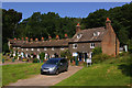
Carter's Cottages, Kings Avenue
A row of early 19th century cottages below Redhill Common, in the St Johns Conservation Area. This area was originally known as Little London, before taking the name of the nearby church when this was built in the mid 19th century.
Image: © Ian Capper
Taken: 7 Jun 2008
0.00 miles
2
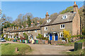
Carter's Cottages, Kings Avenue
A row of early 19th century cottages below Redhill Common, in the St Johns Conservation Area. This area was originally known as Little London, before taking the name of the nearby church when this was built in the mid 19th century.
Image: © Ian Capper
Taken: 19 Apr 2021
0.01 miles
3
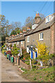
Carter's Cottages, Kings Avenue
A row of early 19th century cottages below Redhill Common, in the St Johns Conservation Area. This area was originally known as Little London, before taking the name of the nearby church when this was built in the mid 19th century.
Image: © Ian Capper
Taken: 19 Apr 2021
0.01 miles
4
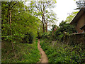
Path south down edge of Redhill Common
A house reached from Fairlawn Drive is on the right.
Image: © Robin Webster
Taken: 21 Apr 2018
0.05 miles
5
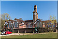
St John's Primary School
Founded in 1845, the current building is a replacement of the original and dates from 1910.
Image: © Ian Capper
Taken: 19 Apr 2021
0.06 miles
6
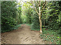
Path north up edge of Redhill Common
The common boundary is on the left.
Image: © Robin Webster
Taken: 21 Apr 2018
0.06 miles
7
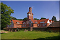
St John's Primary School
Founded in 1845, the building in this photo is a replacement of the original and dates from 1910.
Image: © Ian Capper
Taken: 7 Jun 2008
0.06 miles
8
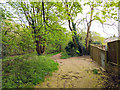
Path south down edge of Redhill Common
A small electrical substation is on the right.
Image: © Robin Webster
Taken: 21 Apr 2018
0.06 miles
9
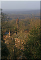
St John's School from Redhill Common
The tower of St Johns School is seen behind the cottages in Kings Avenue (see Image and Image respectively).
Image: © Ian Capper
Taken: 15 Mar 2009
0.06 miles
10
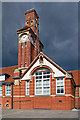
St John's Primary School
Part of the 1910 buildings, including the prominent clock tower. See Image for a wider view.
Image: © Ian Capper
Taken: 12 Sep 2010
0.06 miles