IMAGES TAKEN NEAR TO
Whitepost Hill, REDHILL, RH1 6PE
Introduction
This page details the photographs taken nearby to Whitepost Hill, RH1 6PE by members of the Geograph project.
The Geograph project started in 2005 with the aim of publishing, organising and preserving representative images for every square kilometre of Great Britain, Ireland and the Isle of Man.

There are currently over 7.5m images from over14,400 individuals and you can help contribute to the project by visiting https://www.geograph.org.uk
Image Map
Images are licensed for reuse under creativecommons.org/licenses/by-sa/2.0
Notes
- Clicking on the map will re-center to the selected point.
- The higher the marker number, the further away the image location is from the centre of the postcode.
Image Listing (139 Images Found)
Images are licensed for reuse under creativecommons.org/licenses/by-sa/2.0
Image
Details
Distance
1
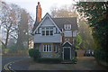
Former Lodge, Whitepost Hill
Former Lodge to Garlands, a large house that stood nearby. Although its address is Whitepost Hill, it is in fact situated in Ridgeway Road. Built in 1871, it is locally listed.
Image: © Ian Capper
Taken: 20 Nov 2011
0.02 miles
2
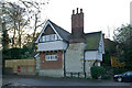
Former Lodge, Whitepost Hill
Former Lodge to Garlands, a large house that stood nearby. Although its address is Whitepost Hill, it is in fact situated in Ridgeway Road. Built in 1871, it is locally listed.
Image: © Ian Capper
Taken: 27 Nov 2011
0.02 miles
3

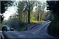
Whitepost Hill
The sun's rays lighting up the junction of Whitepost Hill with Linkfield Street on a misty morning.
Image: © Ian Capper
Taken: 20 Nov 2011
0.02 miles
4
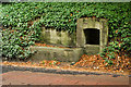
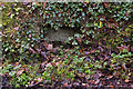
Water trough, Mill Street
For many years, this water trough was hidden by ivy. Redhill Common has a number of springs around it, and it is likely that this trough was originally spring fed. For wider view, see Image
Image: © Ian Capper
Taken: 9 Oct 2011
0.02 miles
5
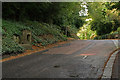
Mill Street
At its junction with Linkfield Street (on the right), at which point it becomes Whitepost Hill (in the background). On the left is part of Redhill Common. For close up of the water trough on the left, see Image
Image: © Ian Capper
Taken: 9 Oct 2011
0.02 miles
6
Road Junction on Redhill Common, Surrey
Mill Street continues, down the hill, whilst Sandpit Road peels off to the right.
Image: © Peter Trimming
Taken: 14 Jan 2012
0.05 miles
7
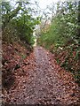
Whitepost Hill Spring
One of a number of springs around Redhill Common - see Image for another one. For wider view of site see Image Now very overgrown so as to be hardly visible, the stone structure is the remains of a surround to the spring itself, which nowadays is usually dry.
Image: © Ian Capper
Taken: 20 Nov 2011
0.07 miles
9
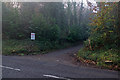
Drive to Blackstone
Driveway off Whitepost Hill leading to a group of large houses on Redhill Common. Below the sign is the spring shown in Image
Image: © Ian Capper
Taken: 20 Nov 2011
0.08 miles
10
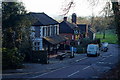
The Garibaldi, Redhill Common, Surrey
Situated on Mill Street, at the edge of Redhill Common.
Image: © Peter Trimming
Taken: 14 Jan 2012
0.09 miles