IMAGES TAKEN NEAR TO
Copse Road, REDHILL, RH1 6NW
Introduction
This page details the photographs taken nearby to Copse Road, RH1 6NW by members of the Geograph project.
The Geograph project started in 2005 with the aim of publishing, organising and preserving representative images for every square kilometre of Great Britain, Ireland and the Isle of Man.

There are currently over 7.5m images from over14,400 individuals and you can help contribute to the project by visiting https://www.geograph.org.uk
Image Map
Images are licensed for reuse under creativecommons.org/licenses/by-sa/2.0
Notes
- Clicking on the map will re-center to the selected point.
- The higher the marker number, the further away the image location is from the centre of the postcode.
Image Listing (81 Images Found)
Images are licensed for reuse under creativecommons.org/licenses/by-sa/2.0
Image
Details
Distance
1
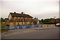
The Ship Inn
There was a pub here before 1869. The present building was built in 1952, set further back from the road to give parking space. It is now due to be demolished.
Image: © Ian Capper
Taken: 27 May 2008
0.00 miles
2
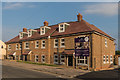
Victory Court
Block of 12 flats in Copse Road, built on the site of the Ship Inn (see Image).
Image: © Ian Capper
Taken: 31 Jul 2014
0.01 miles
3
Victory Court
Block of 12 flats in Copse Road, built on the site of the Ship Inn (see Image).
Image: © Ian Capper
Taken: 31 Jul 2014
0.01 miles
4
Jireh Chapel
A former baptist chapel, built in 1854, rebuilt in 1953. Now a nursery.
Image: © Ian Capper
Taken: 27 May 2008
0.02 miles
5
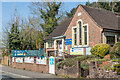
Former Baptist Chapel
A former baptist chapel, built in 1854, rebuilt in 1953, and home to Reigate Baptist Church until they moved to new premises in Sycamore Road in 2005. Now a nursery.
Image: © Ian Capper
Taken: 19 Apr 2021
0.02 miles
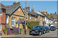
6
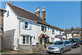
Lower Road
Mid 19th Century cottages in a road linking Hardwick Road with Copse Road.
Image: © Ian Capper
Taken: 19 Apr 2021
0.03 miles
7
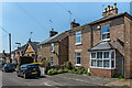
Lower Road
Mainly mid 19th Century cottages in a road linking Hardwick Road with Copse Road. Towards the left is a former Primitive Methodist chapel, with a date plaque of 1855, converted to residential use in c.2003.
Image: © Ian Capper
Taken: 19 Apr 2021
0.04 miles
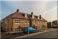
8
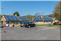
Greystones Close
c.1950s cul-de-sac of retirement bungalows off Hardwick Road, built on land to the rear of Greystone House which served as a children's home, marked as such on maps from the early 20th Century, but redeveloped c.2000 (see Image).
Image: © Ian Capper
Taken: 19 Apr 2021
0.04 miles
9
Lower Road
Mainly mid 19th Century cottages in a road linking Hardwick Road with Copse Road. On the left is a former Primitive Methodist chapel, with a date plaque of 1855, converted to residential use in c.2003.
Image: © Ian Capper
Taken: 19 Apr 2021
0.04 miles
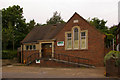
10
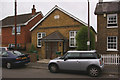
Former chapel, Lower Road, Meadvale
Locally listed former "Primitive Methodist" chapel, built in 1855. It is now a private house.
Image: © Ian Capper
Taken: 21 Jun 2008
0.04 miles