IMAGES TAKEN NEAR TO
Whitepost Hill, REDHILL, RH1 6BD
Introduction
This page details the photographs taken nearby to Whitepost Hill, RH1 6BD by members of the Geograph project.
The Geograph project started in 2005 with the aim of publishing, organising and preserving representative images for every square kilometre of Great Britain, Ireland and the Isle of Man.

There are currently over 7.5m images from over14,400 individuals and you can help contribute to the project by visiting https://www.geograph.org.uk
Image Map
Images are licensed for reuse under creativecommons.org/licenses/by-sa/2.0
Notes
- Clicking on the map will re-center to the selected point.
- The higher the marker number, the further away the image location is from the centre of the postcode.
Image Listing (142 Images Found)
Images are licensed for reuse under creativecommons.org/licenses/by-sa/2.0
Image
Details
Distance
1
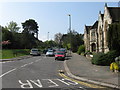
Redhill: Blackborough Road
The eastern end of Blackborough Road, looking southwest from the complicated road junction by the URC church.
Image: © Dr Neil Clifton
Taken: 18 Apr 2011
0.00 miles
2
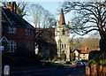
Blackstone Hill, Redhill, Surrey
Looking down Blackstone Hill, from the junction with Whitepost Hill. The United Reformed Church, at the junction with the A25, can be seen.
Image: © Peter Trimming
Taken: 14 Jan 2012
0.00 miles
3
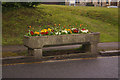
Horse trough
Provided by the Metropolitan Drinking Fountain and Cattle Trough Association. One of four such troughs in Reigate and Redhill. See Image for wider view of location.
It was originally situated in front of St Paul's Church, but was moved in 1923 when the war memorial (see Image) was erected there.
Image: © Ian Capper
Taken: 19 Apr 2008
0.01 miles
4
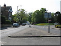
Redhill: Whitepost Hill
This is the lower part of Whitepost Hill seen from its junction with Hatchlands Road
Image: © Dr Neil Clifton
Taken: 18 Apr 2011
0.02 miles
5
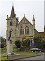
The War Memorial and United Reformed Church
Image: © John Barrett
Taken: 17 Jun 2005
0.02 miles
6
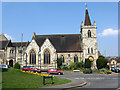
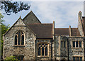
Redhill: United Reformed Church
This nicely-proportioned building is seen to advantage from Whitepost Hill
Image: © Dr Neil Clifton
Taken: 18 Apr 2011
0.03 miles
7
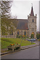
St Pauls United Reformed Church
At Shaws Corner. Built to a design of George Lethbridge, it was opened on 28 May 1902 as Redhill Presbyterian Church. In the foreground can be seen a former water trough from the Metropolitan Drinking Fountain and Cattle Trough Association (see Image for closeup).
Image: © Ian Capper
Taken: 19 Apr 2008
0.03 miles
8
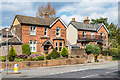
3 & 4 Whitepost Hill
Pair of late Victorian houses in Whitepost Hill.
Image: © Ian Capper
Taken: 12 Apr 2021
0.03 miles
10
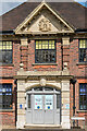
Fa?ade, Pippa's House Nursery
Façade of Pippa's House Nursery, a children's nursery set up in 2019 in the former Shaw's Corner Clinic. According to the local council conservation officer in a response to a planning application, the building dates from 1929, designed by the architect David Barry, although the council conservation area appraisal refers to 1931 and the architect Hooper (presumably Vincent).
For a photo of the whole building see Image and for a close up of the Reigate Borough Council coat of arms in the gable see Image
Image: © Ian Capper
Taken: 12 Apr 2021
0.03 miles