IMAGES TAKEN NEAR TO
Reigate Road, REDHILL, RH1 6BA
Introduction
This page details the photographs taken nearby to Reigate Road, RH1 6BA by members of the Geograph project.
The Geograph project started in 2005 with the aim of publishing, organising and preserving representative images for every square kilometre of Great Britain, Ireland and the Isle of Man.

There are currently over 7.5m images from over14,400 individuals and you can help contribute to the project by visiting https://www.geograph.org.uk
Image Map
Images are licensed for reuse under creativecommons.org/licenses/by-sa/2.0
Notes
- Clicking on the map will re-center to the selected point.
- The higher the marker number, the further away the image location is from the centre of the postcode.
Image Listing (149 Images Found)
Images are licensed for reuse under creativecommons.org/licenses/by-sa/2.0
Image
Details
Distance
1
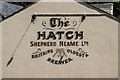
Mural, The Hatch
Mural on wall of The Hatch (see Image).
On 31 August 2012, a lorry had crashed into the wall and the mural was added after the rebuild.
Image: © Ian Capper
Taken: 22 Jun 2014
0.02 miles
2

Devon Crescent
Road dating from the 1890s. Originally called Devon Road, maps suggest that it was given its present name in around the 1930s.
Image: © Ian Capper
Taken: 22 Jun 2014
0.03 miles
3

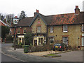
Redhill: The 'Hatch'
Excellent pub serving a selction of real ales and a choice of Belgian beers.
Image: © Dr Neil Clifton
Taken: 18 Apr 2011
0.03 miles
4
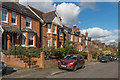
Devon Crescent
Road dating from the 1890s. Originally called Devon Road, maps suggest that it was given its present name in around the 1930s.
Image: © Ian Capper
Taken: 24 Feb 2017
0.03 miles
5
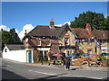
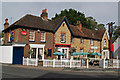
The Hatch, Redhill
A Shepherd Neame pub on Hatchlands Road.
Image: © Oast House Archive
Taken: 6 Oct 2010
0.03 miles
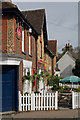
7
The Hatch, Redhill
Originally a wheelwright's shop, it became a pub in the 1850s run by a member of the Shaw family (after whom the junction on which it is situated, Shaw's Corner, was named). The Hatch was its original name, a reference to one of the town gates that is said to have existed close by at one time to prevent animals straying too far along the road. For most of its life it was called the Foresters' Arms, before reverting to the Hatch. Locally listed.
Image: © Ian Capper
Taken: 23 Feb 2008
0.03 miles
8
The Hatch
Originally a wheelwright's shop, it became a pub in the 1850s run by a member of the Shaw family (after whom the junction on which it is situated, Shaw's Corner, was named). The Hatch was its original name, a reference to one of the town gates that is said to have existed close by at one time to prevent animals straying too far along the road. For most of its life it was called the Foresters' Arms, before reverting to the Hatch. Locally listed.
Image: © Ian Capper
Taken: 9 Oct 2011
0.03 miles
9
The Hatch
Originally a wheelwright's shop, it became a pub in the 1850s run by a member of the Shaw family (after whom the junction on which it is situated, Shaw's Corner, was named). The Hatch was its original name, a reference to one of the town gates that is said to have existed close by at one time to prevent animals straying too far along the road. For most of its life it was called the Foresters' Arms, before reverting to the Hatch. Locally listed.
Image: © Ian Capper
Taken: 9 Oct 2011
0.03 miles
10
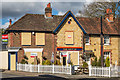
The Hatch - closed
Originally a wheelwright's shop, it became a pub in the 1850s run by a member of the Shaw family (after whom the junction on which it is situated, Shaw's Corner, was named). The Hatch was its original name, a reference to one of the town gates that is said to have existed close by at one time to prevent animals straying too far along the road. For most of its life it was called the Foresters' Arms, before reverting to the Hatch. Locally listed.
In this photo, the windows are boarded up and most of the signage has been removed, following the closure of the pub on 6 January 2017.
Image: © Ian Capper
Taken: 24 Feb 2017
0.03 miles