IMAGES TAKEN NEAR TO
Waterslade, Elm Road, REDHILL, RH1 6AS
Introduction
This page details the photographs taken nearby to Waterslade, Elm Road, RH1 6AS by members of the Geograph project.
The Geograph project started in 2005 with the aim of publishing, organising and preserving representative images for every square kilometre of Great Britain, Ireland and the Isle of Man.

There are currently over 7.5m images from over14,400 individuals and you can help contribute to the project by visiting https://www.geograph.org.uk
Image Map
Images are licensed for reuse under creativecommons.org/licenses/by-sa/2.0
Notes
- Clicking on the map will re-center to the selected point.
- The higher the marker number, the further away the image location is from the centre of the postcode.
Image Listing (170 Images Found)
Images are licensed for reuse under creativecommons.org/licenses/by-sa/2.0
Image
Details
Distance
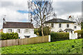
1
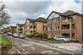
Waterslade
Late 1980s development of flats in 5 blocks in Elm Road, replacing 4 detached Edwardian houses used as nurses' accommodation.
Image: © Ian Capper
Taken: 1 Mar 2020
0.01 miles
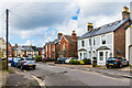
2
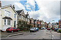
Fengates Road
Late Victorian housing in Fengates Road.
Image: © Ian Capper
Taken: 1 Mar 2020
0.04 miles
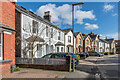
3
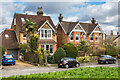
1 and 3 Elm Road
Pair of Edwardian houses on Elm Road.
Image: © Ian Capper
Taken: 1 Mar 2020
0.05 miles
4
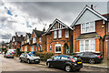
Fengates Road
Late Victoriana housing in Fengates Road.
Image: © Ian Capper
Taken: 1 Mar 2020
0.05 miles
5
Fengates Road
Late Victorian housing in Fengates Road.
Image: © Ian Capper
Taken: 1 Mar 2020
0.05 miles
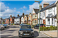
6
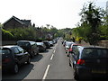
Redhill: Ranelagh Road
Looking south from its junction with Hatchlands Road
Image: © Dr Neil Clifton
Taken: 18 Apr 2011
0.06 miles
7
Fengates Road
Late Victorian housing in Fengates Road.
Image: © Ian Capper
Taken: 1 Mar 2020
0.06 miles
8
9 and 10 Whitepost Hill
Pair of Victorian houses on Whitepost Hill (although accessed off Elm Road). No 10, on the right, is grade II listed - see www.historicengland.org.uk/listing/the-list/list-entry/1189195.
Image: © Ian Capper
Taken: 1 Mar 2020
0.06 miles
9

Whitepost Hill
These houses are unusual, in that whilst their address is Whitepost Hill, they are more readily accessed off Elm Road (seen here in the background), with what is more usually considered as Whitepost Hill being the road to the south (shown in yellow on the 1:50,000 map).
Image: © Ian Capper
Taken: 12 Sep 2010
0.06 miles
10
Fengates Road
Late Victorian housing in Fengates Road.
Image: © Ian Capper
Taken: 1 Mar 2020
0.06 miles