IMAGES TAKEN NEAR TO
Hatchlands Road, REDHILL, RH1 6AA
Introduction
This page details the photographs taken nearby to Hatchlands Road, RH1 6AA by members of the Geograph project.
The Geograph project started in 2005 with the aim of publishing, organising and preserving representative images for every square kilometre of Great Britain, Ireland and the Isle of Man.

There are currently over 7.5m images from over14,400 individuals and you can help contribute to the project by visiting https://www.geograph.org.uk
Image Map
Images are licensed for reuse under creativecommons.org/licenses/by-sa/2.0
Notes
- Clicking on the map will re-center to the selected point.
- The higher the marker number, the further away the image location is from the centre of the postcode.
Image Listing (163 Images Found)
Images are licensed for reuse under creativecommons.org/licenses/by-sa/2.0
Image
Details
Distance
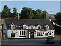
1
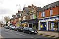
Raffles Bridge
Raffles Bridge, just visible beyond the shops, is where the A25 Reigate-Redhill road crosses the railway connecting the two towns. It is also the name commonly applied to this small area of shops either side of the bridge. It is in fact a misnomer, and should properly be spelt ‘Reffell's Bridge’ after Henry Reffell who ran a brewery here in the mid 19th century.
Image: © Ian Capper
Taken: 14 Nov 2009
0.01 miles
2
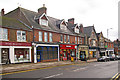
Raffles Bridge
Raffles Bridge, behind the photographer's position, is where the A25 Reigate-Redhill road crosses the railway connecting the two towns. It is also the name commonly applied to this small area of shops either side of the bridge. It is in fact a misnomer, and should properly be spelt ‘Reffell's Bridge’ after Henry Reffell who ran a brewery here in the mid 19th century.
Image: © Ian Capper
Taken: 14 Nov 2009
0.01 miles
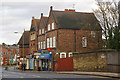
3
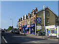
Redhill: Shops, Hatchlands Road
Just east of the railway bridge.
Image: © Dr Neil Clifton
Taken: 18 Apr 2011
0.04 miles
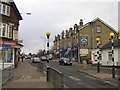
4
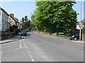
Redhill: Hatchlands Road
Looking west from the railway bridge
Image: © Dr Neil Clifton
Taken: 18 Apr 2011
0.05 miles
6
Raffles Bridge
Raffles Bridge, on the right, is where the A25 Reigate-Redhill road crosses the railway connecting the two towns. It is also the name commonly applied to this small area of shops either side of the bridge. It is in fact a misnomer, and should properly be spelt ‘Reffell's Bridge’ after Henry Reffell who ran a brewery here in the mid 19th century.
Image: © Ian Capper
Taken: 14 Nov 2009
0.05 miles
7
Raffles Bridge, Redhill
Raffles Bridge, at the top of the slope in the middle of this picture, is where the A25 Reigate-Redhill road crosses the railway connecting the two towns. It is also the name commonly applied to this small area of shops either side of the bridge. It is in fact a misnomer, and should properly be spelt ‘Reffell's Bridge’ after Henry Reffell who ran a brewery here in the mid 19th century.
Image: © Ian Capper
Taken: 23 Feb 2008
0.06 miles
8
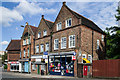
Raffles Bridge shops
Row of shops on Raffles Bridge. In the background on the left of the photo is The Dome (see Image).
Image: © Ian Capper
Taken: 16 Jun 2013
0.06 miles
9
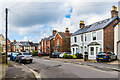
Fengates Road
Late Victorian housing in Fengates Road.
Image: © Ian Capper
Taken: 1 Mar 2020
0.07 miles
10
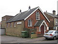
Shrewsbury Chapel, Redhill
A Brethren chapel in Shrewsbury Road, opened on 3 December 1888.
Image: © Ian Capper
Taken: 23 Feb 2008
0.07 miles