IMAGES TAKEN NEAR TO
Franklynn Road, HAYWARDS HEATH, RH16 4SQ
Introduction
This page details the photographs taken nearby to Franklynn Road, RH16 4SQ by members of the Geograph project.
The Geograph project started in 2005 with the aim of publishing, organising and preserving representative images for every square kilometre of Great Britain, Ireland and the Isle of Man.

There are currently over 7.5m images from over14,400 individuals and you can help contribute to the project by visiting https://www.geograph.org.uk
Image Map
Images are licensed for reuse under creativecommons.org/licenses/by-sa/2.0
Notes
- Clicking on the map will re-center to the selected point.
- The higher the marker number, the further away the image location is from the centre of the postcode.
Image Listing (73 Images Found)
Images are licensed for reuse under creativecommons.org/licenses/by-sa/2.0
Image
Details
Distance
1
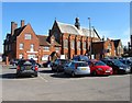
Kents Road Church, Kents Road, Haywards Heath
The meeting place of the Plymouth Brethren that was established here in the late 1930s having originally been located in South Road.
Image: © Simon Carey
Taken: 7 Apr 2015
0.03 miles
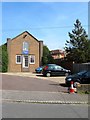
2
Franklynn Court, Franklynn Road, Haywards Heath
Built in the early 1970s on the site of Berry's coal yard.
Image: © Simon Carey
Taken: 7 Apr 2015
0.05 miles
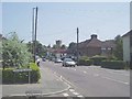
3
Whitelands
Built in the late 1980s on the site of a former builders yard owned by Thomas White Ltd that had occupied the spot from the early part of the century to the 1980s and had been responsible for building a fair proportion of the current town. The white building to the left was the old site office and is now a chartered accountants. Taken from the junction with Franklynn Road (A272).
Image: © Simon Carey
Taken: 30 Aug 2007
0.05 miles
4
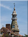
Water Tower and the road east out of Haywards Heath
The water tower marks the highest point in the town and nearby is the Princess Royal Hospital linked to The Royal Sussex County Hospital at Brighton.
Image: © Nigel Freeman
Taken: 27 Jun 2005
0.06 miles
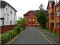
5
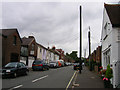
Triangle Road
One of the earliest roads established in Haywards Heath linking the road to Uckfield with that to Wivelsfield across a small piece of land known as the Triangle. Houses and shops were established in this road by the early 1870s.
Image: © Simon Carey
Taken: 30 Aug 2007
0.06 miles
6
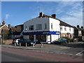
Off Licence, Franklynn Road
On the junction of the A272 and Western Road. There has been one here, albeit under different names, since at least the 1970s
Image: © Simon Carey
Taken: 10 Apr 2011
0.06 miles
9
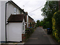
Petlands Gardens
Late Victorian terraced cottages in a small cul-de-sac off Franklynn Road though a footpath at the bottom connects to Kents Road.
Image: © Simon Carey
Taken: 30 Aug 2007
0.07 miles
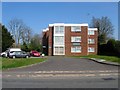
10
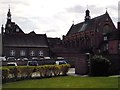
Franklynn Road Car Park, Haywards Heath
From the late 19th century to at least the end of the 1960s this was the site of a small nursery. Certainly by the early 1970s when I regularly walked along Franklynn Road it had become a car park. Beyond is the former Priory.
Image: © Simon Carey
Taken: 7 Mar 2015
0.07 miles