IMAGES TAKEN NEAR TO
Butlers Green Road, HAYWARDS HEATH, RH16 4BD
Introduction
This page details the photographs taken nearby to Butlers Green Road, RH16 4BD by members of the Geograph project.
The Geograph project started in 2005 with the aim of publishing, organising and preserving representative images for every square kilometre of Great Britain, Ireland and the Isle of Man.

There are currently over 7.5m images from over14,400 individuals and you can help contribute to the project by visiting https://www.geograph.org.uk
Image Map
Images are licensed for reuse under creativecommons.org/licenses/by-sa/2.0
Notes
- Clicking on the map will re-center to the selected point.
- The higher the marker number, the further away the image location is from the centre of the postcode.
Image Listing (89 Images Found)
Images are licensed for reuse under creativecommons.org/licenses/by-sa/2.0
Image
Details
Distance
1
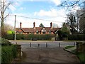
James Bradford Almshouses, Butlers Green Road, Haywards Heath
Six in total built by Sir James Bradford in 1910. Very similar in style to his almshouses in Helpston, see Image Bradford also donated land to the west for the construction of a hospital. Still used as sheltered housing today.
Image: © Simon Carey
Taken: 30 Mar 2015
0.01 miles
2
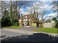
Wychpery Bower, Butlers Green Road, Haywards Heath
Built between the wars on what was previously Vinals Field, according to Cuckfield's 1843 tithe map. Vinals was the old name of the house that later became Image
Image: © Simon Carey
Taken: 31 Mar 2015
0.03 miles
3
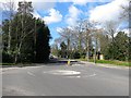
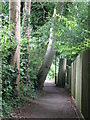
Butlers Green Road, Haywards Heath
Up to the autumn of 2014 it was the A272 which has now been rerouted to the south of the town with the old course redesigned the B2272. The road runs from the western end of Muster Green to the junction with Isaac's Lane which was the former location of Butlers Green after which it becomes Tylers Green. Viewed from the junction with Bolnore Road.
Image: © Simon Carey
Taken: 31 Mar 2015
0.03 miles
4
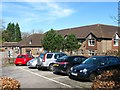
Beech Hurst, Butlers Green Road, Haywards Heath
A purpose built care home built in the grounds of the former Haywards Heath Hospital.
Image: © Simon Carey
Taken: 12 Apr 2015
0.04 miles
7
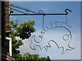
(Another) sign for The Dolphin
Image: © Mike Quinn
Taken: 12 Aug 2008
0.05 miles
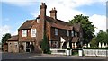
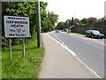
9
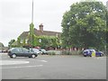
Dolphin Public House
This was known as the Sergison Arms (The Sarge) since 1840s but became the Dolphin in the 1990s. It is opposite Haywards Heath police station so no rowdiness please!
Image: © Nigel Freeman
Taken: 2 Jul 2005
0.05 miles
10
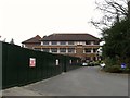
Police Station, Bolnore Road, Haywards Heath
The original police station was in Paddockhall Road from 1887 until its move here in the late 1980s along with the neighbouring law courts which have recently been demolished. A house called Elfinsward originally stood here from its construction in the 1860s to its demolition in 1973, having been purchased by the Sussex police authorities who then spent a number of years in legal wrangles trying to develop the site.
Image: © Simon Carey
Taken: 30 Mar 2015
0.05 miles