IMAGES TAKEN NEAR TO
Calbourne, HAYWARDS HEATH, RH16 4AQ
Introduction
This page details the photographs taken nearby to Calbourne, RH16 4AQ by members of the Geograph project.
The Geograph project started in 2005 with the aim of publishing, organising and preserving representative images for every square kilometre of Great Britain, Ireland and the Isle of Man.

There are currently over 7.5m images from over14,400 individuals and you can help contribute to the project by visiting https://www.geograph.org.uk
Image Map
Images are licensed for reuse under creativecommons.org/licenses/by-sa/2.0
Notes
- Clicking on the map will re-center to the selected point.
- The higher the marker number, the further away the image location is from the centre of the postcode.
Image Listing (98 Images Found)
Images are licensed for reuse under creativecommons.org/licenses/by-sa/2.0
Image
Details
Distance
1
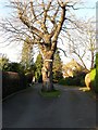
Calbourne, Haywards Heath
A small private cul de sac off Muster Green North built in the 1950s.
Image: © Simon Carey
Taken: 8 Feb 2015
0.01 miles
3
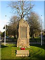
War Memorial, Muster Green, Haywards Heath
Positioned at the western tip of Muster Green formerly part of the large common that formed the original Haywards Heath and said to be the meeting place over the centuries of the local militia.
Image: © Simon Carey
Taken: 8 Feb 2015
0.05 miles
4
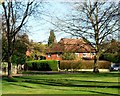
Muster Green North, Haywards Heath
The name of the road that runs along the northern side of Muster Green that is now closed at the western end after the opening of Image in 1968.
Image: © Simon Carey
Taken: 8 Feb 2015
0.05 miles
5
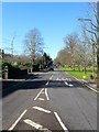
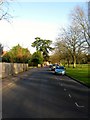
Muster Green South, Haywards Heath
Since autumn 2014 this has been the B2272 after the opening of the Haywards Heath bypass to the south that finally takes the busy 272 out of the town. The road itself predates the town and was the old medieval road from Cuckfield to the east which passed a former common called Muster Green the remnants of which have now become an open space on the right.
Image: © Simon Carey
Taken: 17 Feb 2015
0.05 miles
6
Muster Green Haywards Heath
Alongside the A272 which is on the right.
Image: © Dave Spicer
Taken: 7 Sep 2012
0.06 miles
7
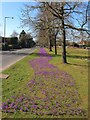
Spring, Muster Green, Haywards Heath
Plants beginning to bloom on muster Green adjacent to the former A272.
Image: © Simon Carey
Taken: 7 Mar 2015
0.06 miles
8
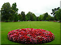
Muster Green
The site of the Battle of Haywards Heath fought in December 1642 when a Royalist force under Sir Edward Ford of Uppark attempted to march on Lewes having secured Chichester was stopped by Sir William Waller at the cost of 200 Royalist dead. The green is still maintained by the council with the A272 to the south of it.
Image: © Simon Carey
Taken: 30 Aug 2007
0.07 miles
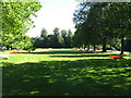
9
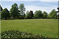
Muster Green
Green space maintained by Haywards Heath Town Council.
Image: © Bill Boaden
Taken: 11 May 2018
0.08 miles
10
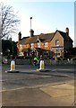
Sergison Arms, Butlers Green Road, Haywards Heath
The building dates from the 16th century and was originally known as Vinalls which it retained at least up to 1809. By 1832 it had been converted into the Dolphin Inn, possibly taking advantage of the east-west turnpike that had opened in 1825 that later became the A272. By 1845 it had become the Sergison Arms which it remained until the 1990s when it reverted to the Dolphin again. About five years ago it once more became the Sergison. The name derives from a family of local landowners whose emblem contained a dolphin. The pub is located at the junction of the former A272 and Paddockhall Road both highways that predate the town. The latter was called Paddock Lane on a 1638 estate map.
Image: © Simon Carey
Taken: 8 Feb 2015
0.08 miles