1
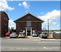
Robins Nest Day Nursery, Perrymount Road, Haywards Heath
Built in the mid 1860s and one of the few survivors of buildings from that period along this road, see
Image, many of which have now been demolished and their grounds turned into office blocks.
Image: © Simon Carey
Taken: 1 Feb 2015
0.01 miles
2
Haywards Heath Methodist Church, Perrymount Road, Haywards Heath
Opened in 1900 and still standing today in a road that has lost much to large office blocks.
Image: © Simon Carey
Taken: 31 Mar 2015
0.02 miles
3
34-36, Perrymount Road, Haywards Heath
Numbers 34-36 were originally a pair of semi-detached Victorian houses which were demolished to make way for this office block originally known as Chalegrove House but now called PNC House after the firm currently occupying it.
Image: © Simon Carey
Taken: 31 Mar 2015
0.03 miles
4
Arlington and Bodiam Courts, Haywards Heath
Privately-owned flats in Haywards Heath. This development is close to the railway station, making it attractive to commuters travelling to London.
Image: © Malc McDonald
Taken: 15 Jan 2011
0.05 miles
5
Haywards Heath Station Car Park
view from platform 1
Image: © Paul Gillett
Taken: 30 Apr 2011
0.05 miles
6
Clair Road, Haywards Heath
The original access road to Haywards Heath station and known until the 1930s as Station Road. It contained a pub, the Liverpool Arms and a number of small cottages all of which have now been cleared, the cottages went in the 1960s and the former pub was finally demolished about a decade ago. By then the station had been rebuilt in the 1930s with a new entrance next to Commercial Square. The former goods yard and land east of the railway is about to be redeveloped again, with a new station entrance and a multi-storey car park. The building on the right is Clevelands which was built on the site of a former filling station.
Image: © Simon Carey
Taken: 1 Feb 2015
0.05 miles
7
Office Blocks, Perrymount Road, Haywards Heath
A number of the original Victorian villas which once lined this road have now disappeared and been replaced by large office blocks. 31-33, partially obscured by the foliage is occupied by Lloyds Bank, 35 is also known as Oakfield House and is let to a number of different business, 37-39 is home to estate and letting agents Savills. Perrymount Road itself predates the town and is currently the B2028.
Image: © Simon Carey
Taken: 1 Feb 2015
0.05 miles
8
Multi-Storey Car Park, Haywards Heath Station
Built as part of the development of the site on the eastern side of Haywards Heath station. Much of the former extensive goods yard has long been used as a car park which has now been replaced by a new multi-storey block which will open in August. Much of the foreground will be redeveloped as part of a car park for a new Waitrose as well as improved vehicle access routes to replace the current forecourt opened in the 1930s. The Cycle Hub on the right is also to close with all cycle bays to moved to the new car park. The redevelopment plans also include the possibility of the Bluebell Railway eventually connecting to the main network.
Image: © Simon Carey
Taken: 18 Jul 2015
0.06 miles
9
Arlington Court, Perrymount Road, Haywards Heath
Built in the 1980s on the site of numbers 24-26 Perrymount Road. Just visible beyond are the flats of Bodiam Court. Perrymount Road originally contained a number of houses with extensive grounds many of which have been lost to either office development or the construction of flats.
Image: © Simon Carey
Taken: 31 Mar 2015
0.06 miles
10
59, Perrymount Road, Haywards Heath
Built in the 1950s as an auction house and gallery and continued until the late 1990s. Now home to Elan Nursery.
Image: © Simon Carey
Taken: 31 Mar 2015
0.06 miles


