IMAGES TAKEN NEAR TO
St. Pauls On The Green, HAYWARDS HEATH, RH16 3DA
Introduction
This page details the photographs taken nearby to St. Pauls On The Green, RH16 3DA by members of the Geograph project.
The Geograph project started in 2005 with the aim of publishing, organising and preserving representative images for every square kilometre of Great Britain, Ireland and the Isle of Man.

There are currently over 7.5m images from over14,400 individuals and you can help contribute to the project by visiting https://www.geograph.org.uk
Image Map
Images are licensed for reuse under creativecommons.org/licenses/by-sa/2.0
Notes
- Clicking on the map will re-center to the selected point.
- The higher the marker number, the further away the image location is from the centre of the postcode.
Image Listing (37 Images Found)
Images are licensed for reuse under creativecommons.org/licenses/by-sa/2.0
Image
Details
Distance
1
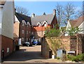
Cilica Mews, Haywards Heath
A small cul de sac of St Paul's on the Green that was developed with the rest of the state in 2007 on the site of a former catholic school. The large building at the end of the close is Damascus Court.
Image: © Simon Carey
Taken: 7 Apr 2015
0.03 miles
2
St Paul's on the Green, Haywards Heath
Developed in 2007, see Image on the site of St Paul's Catholic School that operated here from 1963 until it moved to a new site in Burgess Hill in 2004. St Paul's had previously been Brunswick School a private establishment that had moved from Hove in the late 1880s one of whose pupils was a young Winston Churchill. The school moved to Homestalls near Ashdown Forest in 1958 until the credit crunch forced its closure in 2009. The development is built around a large green which was once part of the school playing fields.
Image: © Simon Carey
Taken: 7 Apr 2015
0.04 miles
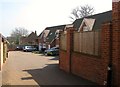
3

Oathall Road Haywards Heath
This is the main road from Lindfield to the Town Centre.
Image: © Dave Spicer
Taken: 7 Sep 2012
0.04 miles
4
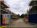
St Pauls in the Meadow, Oathall Avenue
New commuter houses being built on the site of St Paul's Roman Catholic School which opened in 1963 and moved to a new green field site in Burgess Hill in 2004.
Image: © Simon Carey
Taken: 30 Aug 2007
0.05 miles
5
Melita Mews, Haywards Heath
A small cul de sac off St Paul's on the green that was developed in 2007 on the site of a former Roman Catholic school.
Image: © Simon Carey
Taken: 7 Apr 2015
0.07 miles
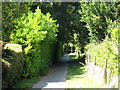
7
The parting of the ways
Just round the corner from the end of Image
Image: © Mike Quinn
Taken: 31 Jul 2008
0.13 miles
8
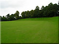
Cricket Field, Heath Recreation Ground
Excavated, laid out and opened in 1897 on a former boggy patch of land, the banks and seats on the eastern side providing an elevated view of the action. The pavilion and scoreboard are behind the photographer.
Image: © Simon Carey
Taken: 30 Aug 2007
0.13 miles
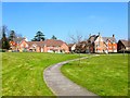
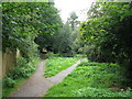
10
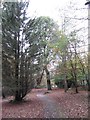
Path in Haywards Heath Recreation Ground
Image: © Gareth James
Taken: 6 Nov 2011
0.16 miles