IMAGES TAKEN NEAR TO
The Platt, HAYWARDS HEATH, RH16 2SY
Introduction
This page details the photographs taken nearby to The Platt, RH16 2SY by members of the Geograph project.
The Geograph project started in 2005 with the aim of publishing, organising and preserving representative images for every square kilometre of Great Britain, Ireland and the Isle of Man.

There are currently over 7.5m images from over14,400 individuals and you can help contribute to the project by visiting https://www.geograph.org.uk
Image Map
Images are licensed for reuse under creativecommons.org/licenses/by-sa/2.0
Notes
- Clicking on the map will re-center to the selected point.
- The higher the marker number, the further away the image location is from the centre of the postcode.
Image Listing (62 Images Found)
Images are licensed for reuse under creativecommons.org/licenses/by-sa/2.0
Image
Details
Distance
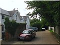
1
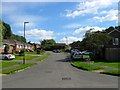
The Platt, Lindfield
A small cul de sac off Image built in the early 1970s.
Image: © Simon Carey
Taken: 6 Sep 2015
0.02 miles
2
America Lane
The original lane that linked Graveleye Lane with the early 19th century allotment colony later known as America. This section from the former down to The Hollow is now a bridleway. To the right are the outbuildings of Graveleye House built in 1826 for William Allen, the founder of America which was designed to enable the poor to become self sufficient through their allotments.
Image: © Simon Carey
Taken: 30 Apr 2011
0.04 miles
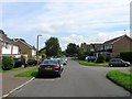
3
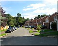
Kiln Lane, Lindfield
A small cul de sac off Image built in the early 1970s.
Image: © Simon Carey
Taken: 6 Sep 2015
0.05 miles
4
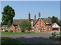
Woodknoll House
I think the house dates from the early 19th century though I'm not certain. Originally sited at the northern tip of Franklands Wood as a country residence the house was swallowed up by the expansion of Haywards Heath during the 1970s with the extensive grounds turned into a small cul-de-sac called Knoll Place sometime during the 1990s.
Image: © Simon Carey
Taken: 30 Apr 2011
0.06 miles
5
America Lane, Lindfield
The lane originally ran west from Gravelye Lane then along what is now Hanbury Lane turned south down what is now Barn Cottage Lane then west again to provide access to a smallholder's settlement originally known as The Colony, nicknamed America by locals which eventually stuck. The cottages were pulled down in 1944 being part of land transferred from Lindfield to Haywards Heath in 1934 and replaced with a new housing estate and a rerouting of the road. This section was downgraded to the status of a bridleway in the late 1960s with the construction of Westlands Road to the north.
The creator of 'America', William Allen, lived in Gravelye House, out of shot to the right, built for him in 1825-26. On the left is what was originally Gravelye Cottage built at the same time as the neighbouring house and now subdivided into two dwellings; Gravelye Cottage to the west and Overmist, originally known as Gravelye Cottage East, to the east.
Image: © Simon Carey
Taken: 6 Sep 2015
0.07 miles
6
The Hollow, Lindfield
An estate developed in the early 1970s that covers the former fields marked on Lindfield's 1845 tithe map as Two Acres, House Field and Hollow Field. Only accessible by vehicle from Westlands Road in the north.
Image: © Simon Carey
Taken: 15 Aug 2015
0.07 miles
7
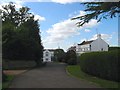
Gravelye Close, Lindfield
A cul de sac off Gravelye Lane built in the grounds of Gravelye House, whose drive is on the left, in the 1990s. White Gables is the house at the far end.
Image: © Simon Carey
Taken: 6 Sep 2015
0.08 miles
8
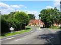
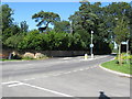
Gravelye Lane, Lindfield
An old lane that originally ran south from Lewes Road then through Franklands Wood to the former Franklands Farm at Birch Green. Much of the latter now lies beneath suburban Haywards Heath whilst the road now becomes Northlands Avenue over the parish boundary its former route through the 1930s Franklands Village now closed to traffic from the north. The two road junctions on the right are Lyoth Lane, an old country lane that runs east to Lyoth Common, and Langmore Lane, a new development recently completed.
Image: © Simon Carey
Taken: 6 Sep 2015
0.09 miles
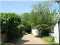
9
Bridleway sign on Gravelye Lane
The bridleway travels a short distance to The Hollows.
Image: © Dave Spicer
Taken: 7 Sep 2012
0.09 miles
10
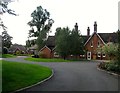
Knoll Place, Lindfield
A cul de sac off Gravelye Lane that was built in 2001 in the former grounds of Wood Knoll House, a large Victorian house built between 1845 and 1875, which still exists as a single residence on the right.
Image: © Simon Carey
Taken: 6 Sep 2015
0.10 miles