IMAGES TAKEN NEAR TO
Spring Lane, HAYWARDS HEATH, RH16 2RF
Introduction
This page details the photographs taken nearby to Spring Lane, RH16 2RF by members of the Geograph project.
The Geograph project started in 2005 with the aim of publishing, organising and preserving representative images for every square kilometre of Great Britain, Ireland and the Isle of Man.

There are currently over 7.5m images from over14,400 individuals and you can help contribute to the project by visiting https://www.geograph.org.uk
Image Map
Images are licensed for reuse under creativecommons.org/licenses/by-sa/2.0
Notes
- Clicking on the map will re-center to the selected point.
- The higher the marker number, the further away the image location is from the centre of the postcode.
Image Listing (109 Images Found)
Images are licensed for reuse under creativecommons.org/licenses/by-sa/2.0
Image
Details
Distance
2
Row of cottages by footpath at the north end of Lindfield
Image: © Dave Spicer
Taken: 6 Jun 2009
0.05 miles
3
Field view at Field View
On the definitive map this is called Field View.
Image: © Dave Spicer
Taken: 10 Jul 2011
0.07 miles
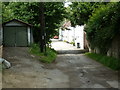
5
House construction on Spring Lane Lindfield
Image: © Dave Spicer
Taken: 10 Jul 2011
0.07 miles
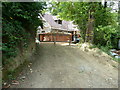
6
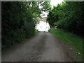
Spring Lane is also the footpath to Fullingmill Farm
Along Spring Lane is a row of cottages Image
Image: © Dave Spicer
Taken: 6 Jun 2009
0.08 miles
7
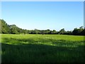
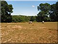
Pit Field/Further Field
The name of the fields according to Lindfield's 1845 tithe map that have been merged along with two others to form a larger unit. Two unnamed fields originally lay in strips adjacent to the B2028 with Pit Field beyond and Further Field located at the western end. To the south is the line of the bandoned Ouse Valley Railway whilst to the north is the River Ouse.
Image: © Simon Carey
Taken: 4 Aug 2015
0.09 miles
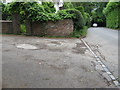
8

171, High Street, Lindfield
Also known as the Clock House, it is located on the corner of High Street and Spring Lane and dating back to the late 15th century though it was extensively remodelled in a gothic style in the 19th. The last house on the western side in Lindfield before the road out descends down to the Ouse.
Image: © Simon Carey
Taken: 4 Aug 2015
0.11 miles
9
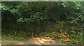
Brick Work, Town Hill, Lindfield
The relics of the abandoned Ouse Valley Railway are located on the western side of the B2028 at the foot of the hill prior to the road entering the Ouse flood plain. A bridge was built here along with plans to construct a station for Lindfield. The railway was never competed, the whole idea behind it was to prevent other companies muscling their way into LBSCR territory by gaining an act of Parliament to construct it then build it as slowly as possible. Worked commenced in 1866 and was stopped the following year after a major railway financing bank collapsed. The bridge was marked on the 1875 OS map but had been pulled down by the 1897 edition with all brick work later removed on the eastern side to make the bend in the road safer, see Image
Image: © Simon Carey
Taken: 4 Aug 2015
0.11 miles
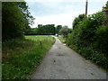
10
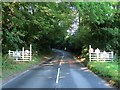
Town Hill, Lindfield
The name of the B2028 from Lindfield Bridge to the junction with Spring Lane whereupon it becomes High Street. Beyond the welcoming gates at the southern end of the Ouse flood plain would have been point where the Ouse Valley Railway would have crossed the road as well as providing the location for Lindfield station. The railway commenced in 1866 and was abandoned in 1867, the bridge remained until the late 19th century when it was removed with the brick work on the eastern side removed altogether when the bend in view was made easier to negotiate. Some brick work still remains on the western side, see Image
Image: © Simon Carey
Taken: 4 Aug 2015
0.12 miles