IMAGES TAKEN NEAR TO
East Mascalls Lane, HAYWARDS HEATH, RH16 2QL
Introduction
This page details the photographs taken nearby to East Mascalls Lane, RH16 2QL by members of the Geograph project.
The Geograph project started in 2005 with the aim of publishing, organising and preserving representative images for every square kilometre of Great Britain, Ireland and the Isle of Man.

There are currently over 7.5m images from over14,400 individuals and you can help contribute to the project by visiting https://www.geograph.org.uk
Image Map
Images are licensed for reuse under creativecommons.org/licenses/by-sa/2.0
Notes
- Clicking on the map will re-center to the selected point.
- The higher the marker number, the further away the image location is from the centre of the postcode.
Image Listing (6 Images Found)
Images are licensed for reuse under creativecommons.org/licenses/by-sa/2.0
Image
Details
Distance
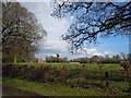
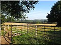
1
Hope Mead
The name of the field according to Lindfield's 1845 tithe map that lies to the east of East Mascalls Lane and north of Great Walstead School.
Image: © Simon Carey
Taken: 9 Aug 2015
0.10 miles
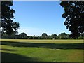
2
Playing fields at Gt Walstead school
Image: © Mark Lindsay-Bayley
Taken: 11 Apr 2012
0.12 miles
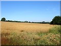
3
Playing Fields, Great Walstead School
Originally a pair of fields called Malthouse Field and Pit Field according to Lindfield's 1845 tithe map. Since 1927 they have been part of the school grounds.
Image: © Simon Carey
Taken: 9 Aug 2015
0.18 miles
4
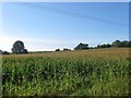
Hop Garden Field
The name of the field according to Lindfield's 1845 tithe map that has been merged with Image to the south and west to form a larger unit. To the east is East Mascalls Lane whilst to the north is Image
Image: © Simon Carey
Taken: 9 Aug 2015
0.22 miles
5
Gate Field
The name of the field according to Lindfield's 1845 tithe map that is located to the west of East Mascalls Lane and south of Image
Image: © Simon Carey
Taken: 9 Aug 2015
0.23 miles
6
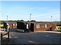
Carter & Faraday Associates, Pelham Farm, East Mascalls Lane
Home to a commercial cleaning company who have been operating since 1978.
Image: © Simon Carey
Taken: 9 Aug 2015
0.24 miles