IMAGES TAKEN NEAR TO
Kempe Road, HAYWARDS HEATH, RH16 2NU
Introduction
This page details the photographs taken nearby to Kempe Road, RH16 2NU by members of the Geograph project.
The Geograph project started in 2005 with the aim of publishing, organising and preserving representative images for every square kilometre of Great Britain, Ireland and the Isle of Man.

There are currently over 7.5m images from over14,400 individuals and you can help contribute to the project by visiting https://www.geograph.org.uk
Image Map
Images are licensed for reuse under creativecommons.org/licenses/by-sa/2.0
Notes
- Clicking on the map will re-center to the selected point.
- The higher the marker number, the further away the image location is from the centre of the postcode.
Image Listing (55 Images Found)
Images are licensed for reuse under creativecommons.org/licenses/by-sa/2.0
Image
Details
Distance
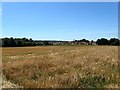
1
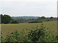
View across fields to houses on the SE corner of Lindfield
Image: © Dave Spicer
Taken: 6 Jun 2009
0.01 miles
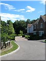
2
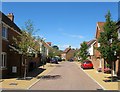
Kempe Road, Lindfield
A newly built residential road that is bookended by Barncroft Drive and is part of the Limes development.
Image: © Simon Carey
Taken: 9 Aug 2015
0.01 miles
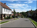
3
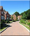
Barncroft Drive, Lindfield
Part of a recently completed Limes estate the road is shaped like the letter 'R' from its single access point off Newton Road. The houses here overlook at Image
Image: © Simon Carey
Taken: 9 Aug 2015
0.03 miles
4
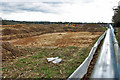
Greenfield development , Lindfield
Lindfield spreads itself east into this field adjacent to existing housing. Totally surrounded by mesh barriers, the photograph was obtained by holding the camera overhead. Also totally surrounded by plastic sheeting, presumably to keep roaming reptiles and amphibians out.
Image: © Robin Webster
Taken: 14 Mar 2010
0.04 miles
5
Old Orchard Close, Lindfield
A small and recently built cul de sac off Barncroft Drive with Beggars Grove, the wood beyond. Part of the new Limes development.
Image: © Simon Carey
Taken: 9 Aug 2015
0.05 miles
6
Saxon Way, Lindfield
A residential road bookended by Barncroft Drive and part of the new Limes estate. In the distance is Image
Image: © Simon Carey
Taken: 9 Aug 2015
0.05 miles
7
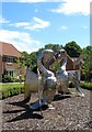
Wills and Kate, Barncroft Drive, Lindfield
Designed by local sculptor Paul Badham, funded by Barratts as part of their newly built Limes estate and unveiled in 2011. Nine foot tall and clad in stainless steel the swans were chosen as being synonymous with Lindfield Pond though there have been none nesting there for a few years.
Image: © Simon Carey
Taken: 9 Aug 2015
0.05 miles
8
The footpath 'behind the church'
This footpath continues all the way to the river Ouse. A popular path for dog owners
Image: © Nigel Freeman
Taken: 12 Jul 2005
0.09 miles
9
White Way Field/Beggars Mead
The name of the fields according to Lindfield's 1845 tithe map that have been combined to form a larger unit. White Way Field is in the foreground whilst Beggars Mead was at the western part of which has been lost to the new Limes development. To the east is Image, to the north is Image and Image, to the west is Image whilst to the south is the wood Beggars Grove.
Image: © Simon Carey
Taken: 9 Aug 2015
0.09 miles
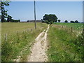
10
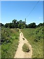
Sussex Ouse Valley Way
Heading towards Lindfield though the original footpath ran to the north of Image with this part not put in place until the 1950s. To the south is Image whilst to the north is Image and Image
Image: © Simon Carey
Taken: 9 Aug 2015
0.11 miles