IMAGES TAKEN NEAR TO
The Wilderness, HAYWARDS HEATH, RH16 2JD
Introduction
This page details the photographs taken nearby to The Wilderness, RH16 2JD by members of the Geograph project.
The Geograph project started in 2005 with the aim of publishing, organising and preserving representative images for every square kilometre of Great Britain, Ireland and the Isle of Man.

There are currently over 7.5m images from over14,400 individuals and you can help contribute to the project by visiting https://www.geograph.org.uk
Image Map
Images are licensed for reuse under creativecommons.org/licenses/by-sa/2.0
Notes
- Clicking on the map will re-center to the selected point.
- The higher the marker number, the further away the image location is from the centre of the postcode.
Image Listing (198 Images Found)
Images are licensed for reuse under creativecommons.org/licenses/by-sa/2.0
Image
Details
Distance
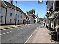
1
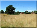
Wilderness Field
A current open space which has a number of paths threading through it to various access points in Lindfield. Not named on the 1845 tithe map but currently known locally after the cul de sac on the western side, The Wilderness. To the north east is Image whilst to the east is Image The tree on the left marks the site of a small pond whilst to the south of it was originally a small strip of allotments.
Image: © Simon Carey
Taken: 9 Aug 2015
0.04 miles
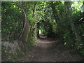
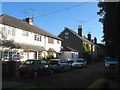
3
The Wilderness, Lindfield
A cul de sac off Brushes Lane that was built in the late 1950s in a planted woodland south of Old Place. Viewed from the junction with the access road to Wilderness Car Park, a long term car parking area for the general public. The house in view is number 1, one of six that exist in the road.
Image: © Simon Carey
Taken: 4 Aug 2015
0.04 miles
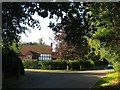
5
Francis Road, Lindfield
A cul de sac off High Street that runs to the east of the church with these terraces developed in the late 19th century. There is access to Image to the south but only by foot.
Image: © Simon Carey
Taken: 4 Aug 2015
0.05 miles
6
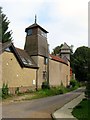
The Pavilion, Francis Road, Lindfield
Erected in 1890 by Charles Eamer Kempe as a purpose built studio for producing his stained glass windows whilst he resided in Image in whose grounds the structure is located. Since the 20th century it has been converted into a residence.
Image: © Simon Carey
Taken: 30 Aug 2015
0.07 miles
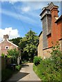
7
Francis Road in Lindfield
I'm not sure what the building is but it could be part of "Old Place", the erstwhile manor house. Francis Road is on the Sussex Ouse Valley Way.
Image: © Shazz
Taken: 21 May 2011
0.07 miles
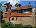
8
Francis Road, Lindfield
A cul de sac that heads south from High Street skirting the church on the eastern side before briefly turning east at this point. On the left are Church View Cottages built in the late 19th century whilst on the right the strange structure is The Pavilion, now a residence but originally built as a studio around 1890 for Charles Eamer Kempe the famous stained glass window artist who resided at Old Place in whose grounds it is located.
Image: © Simon Carey
Taken: 15 Aug 2015
0.07 miles
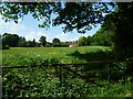
10
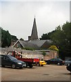
Lindfield - All Saints Church
view from the car park
Church website: http://www.allsaintslindfield.org/
Image: © Paul Gillett
Taken: 10 Jul 2010
0.09 miles