IMAGES TAKEN NEAR TO
Backwoods Lane, HAYWARDS HEATH, RH16 2EQ
Introduction
This page details the photographs taken nearby to Backwoods Lane, RH16 2EQ by members of the Geograph project.
The Geograph project started in 2005 with the aim of publishing, organising and preserving representative images for every square kilometre of Great Britain, Ireland and the Isle of Man.

There are currently over 7.5m images from over14,400 individuals and you can help contribute to the project by visiting https://www.geograph.org.uk
Image Map
Images are licensed for reuse under creativecommons.org/licenses/by-sa/2.0
Notes
- Clicking on the map will re-center to the selected point.
- The higher the marker number, the further away the image location is from the centre of the postcode.
Image Listing (62 Images Found)
Images are licensed for reuse under creativecommons.org/licenses/by-sa/2.0
Image
Details
Distance
1
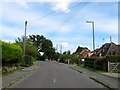
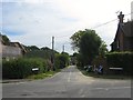
Backwoods Lane, Lindfield
Originally an access road for a former farm, see Image, that was developed in the late 1940s with the road linking up to Appledore Gardens when that was built in the 1960s.
Image: © Simon Carey
Taken: 6 Sep 2015
0.02 miles
2
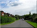
Beckworth Lane, Lindfield
A residential road that heads west off Image that was built in the late 1940s. Viewed from the junction with Image
Image: © Simon Carey
Taken: 6 Sep 2015
0.05 miles
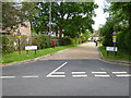
4
Beckworth Close, Lindfield
A private cul de sac off Image that was developed in the late 1940s.
Image: © Simon Carey
Taken: 6 Sep 2015
0.10 miles
5
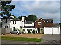
Backwoods, Backwoods Lane, Lindfield
A former farmhouse that now lies buried beneath residential Lindfield. Originally known as Backwood Farm it was the only building between the common and Scrase Stream until the 1940s when its former access road, Backwoods Lane, began to be developed.
Image: © Simon Carey
Taken: 15 Aug 2015
0.10 miles
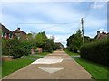
6
Backwoods Close, Lindfield
A cul de sac off Image built through the site of Lindfield Farm during the 1950s.
Image: © Simon Carey
Taken: 6 Sep 2015
0.11 miles
7
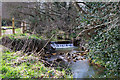
Small weir, Scrase Valley nature reserve
An urban nature reserve in Haywards Heath along the stream valley.
Image: © Robin Webster
Taken: 14 Mar 2010
0.12 miles
8
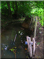
Scrase Stream
A tributary of the River Ouse and a typical Wealden stream in being fast moving when wet that enables it to gouge out the steep banks in view from the clay soil.
Image: © Simon Carey
Taken: 30 Aug 2007
0.12 miles
9

Scrase Valley Nature Reserve
A small local nature reserve encompassing the meadows on the southern side of Scrase Stream, a tributary of the River Ouse. According to Lindfield's 1845 tithe map this was once a field called Five Acre Mead. The land was transferred to Haywards Heath in 1934 with the stream now forming the boundary between the two.
Image: © Simon Carey
Taken: 6 Sep 2015
0.12 miles
10
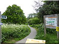
Public footpath going south through Scrace Valley Nature Reserve
Image: © Shazz
Taken: 20 May 2016
0.13 miles