IMAGES TAKEN NEAR TO
Black Hill, HAYWARDS HEATH, RH16 2DU
Introduction
This page details the photographs taken nearby to Black Hill, RH16 2DU by members of the Geograph project.
The Geograph project started in 2005 with the aim of publishing, organising and preserving representative images for every square kilometre of Great Britain, Ireland and the Isle of Man.

There are currently over 7.5m images from over14,400 individuals and you can help contribute to the project by visiting https://www.geograph.org.uk
Image Map
Images are licensed for reuse under creativecommons.org/licenses/by-sa/2.0
Notes
- Clicking on the map will re-center to the selected point.
- The higher the marker number, the further away the image location is from the centre of the postcode.
Image Listing (105 Images Found)
Images are licensed for reuse under creativecommons.org/licenses/by-sa/2.0
Image
Details
Distance
1
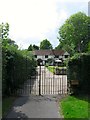
Burnt House Farm, Black Hill, Lindfield
The former farmhouse dates from the 17th century and was built adjacent to Lindfield Common with its own enclosed fields to the rear. Looking at the OS maps it appears to have ceased being a farm towards the end of the 19th century with its former fields now located under the residential estates that lie to the south of the common.
Image: © Simon Carey
Taken: 15 Aug 2015
0.01 miles
2
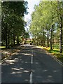
School Lane, Lindfield
The road heads off Backwoods Lane to provide access for St Nicholas' Court and Lindfield Primary School amongst others though originally part of the drive to a large house called Beckworth.
Image: © Simon Carey
Taken: 9 Aug 2015
0.03 miles
3
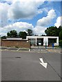
Lindfield Primary Academy
The original primary school was formed in 2000 with the amalgamation of the separate infants and junior schools with the new school located on the expanded site of the former infants that had been built in the 1960s. Conversion to an academy under the University of Brighton Academy Trust took place over the summer of 2015.
Image: © Simon Carey
Taken: 15 Aug 2015
0.04 miles
4
Summers Reach, School Lane, Lindfield
A former outbuilding of Beckworth House that was converted into a residence in 2001.
Image: © Simon Carey
Taken: 15 Aug 2015
0.05 miles
5
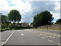
Backwoods Lane, Lindfield
Originally a farm access road over the common to serve Burnthouse and Backwood Farms now lost to residential housing.
Image: © Simon Carey
Taken: 9 Aug 2015
0.06 miles
6
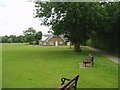
Lindfield Cricket Pavilion
The cricket field is on the common
Image: © Nigel Freeman
Taken: 6 Jul 2005
0.07 miles
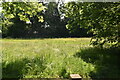
7
Lindfield Common
The western end of the common that lies between Lindfield Primary School to the south, Black Hill, the B2028, to the north, Image to the east and Image to the west.
Image: © Simon Carey
Taken: 15 Aug 2015
0.07 miles
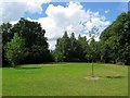
9
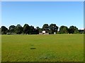
Cricket Pitch, Lindfield Common
Looking across towards the pavilion which is located on the western side of the common. Cricket has been played here since 1747 and the common is currently home to Lindfield CC.
Image: © Simon Carey
Taken: 4 Aug 2015
0.08 miles
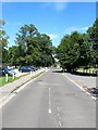
10
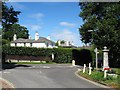
St Anne's, Black Hill, Lindfield
Viewed from the junction with Backwoods Lane the house was built around 1830 and looks out over the common. To the right is a drinking trough and water fountain erected in 1911 as a coronation memorial.
Image: © Simon Carey
Taken: 9 Aug 2015
0.09 miles