IMAGES TAKEN NEAR TO
Cricket Hill, REDHILL, RH1 5SE
Introduction
This page details the photographs taken nearby to Cricket Hill, RH1 5SE by members of the Geograph project.
The Geograph project started in 2005 with the aim of publishing, organising and preserving representative images for every square kilometre of Great Britain, Ireland and the Isle of Man.

There are currently over 7.5m images from over14,400 individuals and you can help contribute to the project by visiting https://www.geograph.org.uk
Image Map
Images are licensed for reuse under creativecommons.org/licenses/by-sa/2.0
Notes
- Clicking on the map will re-center to the selected point.
- The higher the marker number, the further away the image location is from the centre of the postcode.
Image Listing (99 Images Found)
Images are licensed for reuse under creativecommons.org/licenses/by-sa/2.0
Image
Details
Distance
4
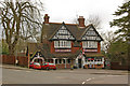
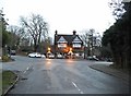
The Station Hotel
A late Victorian pub, built by the Reigate brewery Mellersh & Neale, following the opening of Nutfield Station in 1884.
Image: © Ian Capper
Taken: 6 Mar 2010
0.05 miles
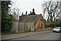
7
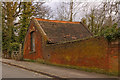
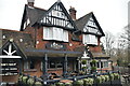
Outbuilding in South Station Approach
To the rear of the Station Hotel (see Image).
Image: © Ian Capper
Taken: 6 Mar 2010
0.06 miles