IMAGES TAKEN NEAR TO
Woolborough Lane, REDHILL, RH1 5QR
Introduction
This page details the photographs taken nearby to Woolborough Lane, RH1 5QR by members of the Geograph project.
The Geograph project started in 2005 with the aim of publishing, organising and preserving representative images for every square kilometre of Great Britain, Ireland and the Isle of Man.

There are currently over 7.5m images from over14,400 individuals and you can help contribute to the project by visiting https://www.geograph.org.uk
Image Map (Loading...)


Getting Data...Please wait
Leaflet Map data © OpenStreetMap
Images are licensed for reuse under creativecommons.org/licenses/by-sa/2.0
Notes
- Clicking on the map will re-center to the selected point.
- The higher the marker number, the further away the image location is from the centre of the postcode.
Image Listing (16 Images Found)
Images are licensed for reuse under creativecommons.org/licenses/by-sa/2.0
Image
Details
Distance
1
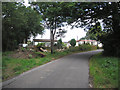
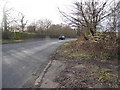
Orchard Farm Mobile Home Park, Woolborough Lane, Surrey
Woolborough Lane is a small remnant of the pre-motorway road network around here. It leads southwards from the main road (Green Lane), just west of the bridge across the M23.
Image: © Dr Neil Clifton
Taken: 1 Aug 2006
0.01 miles
2
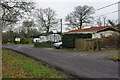
Entrance, Orchard Farm Park
The Park is for chalets and mobile homes.
Image: © Robin Webster
Taken: 27 Jan 2010
0.03 miles
3
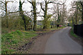
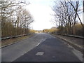
Woolborough Lane
A short cul de sac lane of Green Lane. Note the slipped footpath sign (for close up see Image) - in fact only the bridleway goes off to the right at this point; the footpath continues along the made up lane to the right, which is otherwise a private road.
Image: © Ian Capper
Taken: 27 Mar 2011
0.11 miles
4
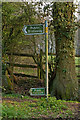
Small people must walk?
What is the explanation for this sign? Is it that it is assumed that very small people will be walking, and so need a sign at their eye level, whereas cyclists and horseriders (and indeed taller walkers) are separately advised of their right of way at their eye level? Or do they have exceptionally tall horses around here? The answer is more mundane - the footpath sign has slipped, not only down the sign but also round it, and in fact refers to a separate route off to the right - see Image
Image: © Ian Capper
Taken: 27 Mar 2011
0.11 miles
6
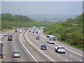
M23 Motorway
from bridge in Green Lane, Outwood. The Nutfield ridge is visible in the distance.
Image: © Roger W Haworth
Taken: 10 May 2006
0.14 miles
7
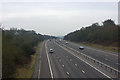
M23 looking south
Only the first 80m of road is in TQ3046, but the view complements the reverse direction geograph here.
Image: © Robin Webster
Taken: 27 Jan 2010
0.14 miles
10
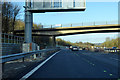
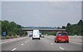
Northbound M23 roadworks at Green Lane Bridge
Most of the M23 is being upgraded to a 'Smart' motorway.
Image: © Robin Webster
Taken: 18 Jan 2020
0.15 miles