IMAGES TAKEN NEAR TO
Scotts Hill, REDHILL, RH1 5PR
Introduction
This page details the photographs taken nearby to Scotts Hill, RH1 5PR by members of the Geograph project.
The Geograph project started in 2005 with the aim of publishing, organising and preserving representative images for every square kilometre of Great Britain, Ireland and the Isle of Man.

There are currently over 7.5m images from over14,400 individuals and you can help contribute to the project by visiting https://www.geograph.org.uk
Image Map
Images are licensed for reuse under creativecommons.org/licenses/by-sa/2.0
Notes
- Clicking on the map will re-center to the selected point.
- The higher the marker number, the further away the image location is from the centre of the postcode.
Image Listing (11 Images Found)
Images are licensed for reuse under creativecommons.org/licenses/by-sa/2.0
Image
Details
Distance
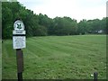
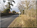
2
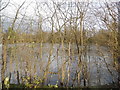
Marl Pond by Scotts Hill, Outwood
Only visible from the road during the winter months
Image: © David Howard
Taken: 29 Mar 2015
0.06 miles
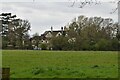
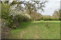
5
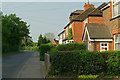
Scott's Hill
A line of cottages on the approach to Outwood Common.
Image: © Ian Capper
Taken: 25 Apr 2011
0.14 miles