IMAGES TAKEN NEAR TO
Outwood Lane, REDHILL, RH1 5PN
Introduction
This page details the photographs taken nearby to Outwood Lane, RH1 5PN by members of the Geograph project.
The Geograph project started in 2005 with the aim of publishing, organising and preserving representative images for every square kilometre of Great Britain, Ireland and the Isle of Man.

There are currently over 7.5m images from over14,400 individuals and you can help contribute to the project by visiting https://www.geograph.org.uk
Image Map
Images are licensed for reuse under creativecommons.org/licenses/by-sa/2.0
Notes
- Clicking on the map will re-center to the selected point.
- The higher the marker number, the further away the image location is from the centre of the postcode.
Image Listing (11 Images Found)
Images are licensed for reuse under creativecommons.org/licenses/by-sa/2.0
Image
Details
Distance
2
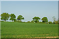
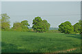
Off Outwood Lane
A young grain crop in a field off Outwood Lane.
Image: © Ian Capper
Taken: 25 Apr 2011
0.11 miles
3
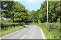
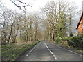
Outwood Lane
Heading into the village centre
Image: © David Howard
Taken: 29 Mar 2015
0.13 miles
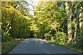
7
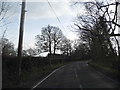
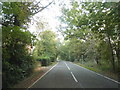
Outwood Lane leaving Outwood
Heading north towards Bletchingley
Image: © David Howard
Taken: 29 Sep 2014
0.15 miles
8
Off Outwood Lane
A young grain crop in a field off Outwood Lane.
Image: © Ian Capper
Taken: 25 Apr 2011
0.19 miles
10
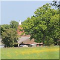
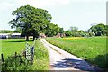
Oast House at Harewood Home Farm, Outwood
Image: © Oast House Archive
Taken: 18 May 2014
0.21 miles