IMAGES TAKEN NEAR TO
Axes Lane, REDHILL, RH1 5JT
Introduction
This page details the photographs taken nearby to Axes Lane, RH1 5JT by members of the Geograph project.
The Geograph project started in 2005 with the aim of publishing, organising and preserving representative images for every square kilometre of Great Britain, Ireland and the Isle of Man.

There are currently over 7.5m images from over14,400 individuals and you can help contribute to the project by visiting https://www.geograph.org.uk
Image Map
Images are licensed for reuse under creativecommons.org/licenses/by-sa/2.0
Notes
- Clicking on the map will re-center to the selected point.
- The higher the marker number, the further away the image location is from the centre of the postcode.
Image Listing (24 Images Found)
Images are licensed for reuse under creativecommons.org/licenses/by-sa/2.0
Image
Details
Distance
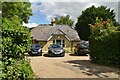
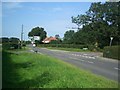
1
Rose Cottages
A pair of semi-detached cottages in Axes Lane, at its junction with Mason's Bridge Road, Picketts Lane and Honeycrock Lane.
Image: © Ian Capper
Taken: 19 Jun 2010
0.01 miles
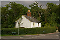
4
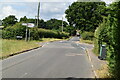
Cross Roads
The junction of Honeycrock Lane, Axes Lane, Mason's Bridge Road and Picketts Lane.
Image: © The Saunterer
Taken: 19 Aug 2012
0.03 miles
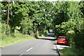
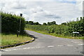
7
Mason's Bridge...looking North
Bridge carries Mason's Bridge Road over Salfords Stream. This stream flows West to join the River Mole.
Image: © Rib
Taken: 14 Jan 2006
0.10 miles
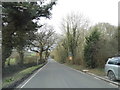
8
Shared Mobile Phone base station
From Picketts Lane
Image: © The Saunterer
Taken: 19 Aug 2012
0.10 miles