IMAGES TAKEN NEAR TO
Petridge Road, REDHILL, RH1 5JG
Introduction
This page details the photographs taken nearby to Petridge Road, RH1 5JG by members of the Geograph project.
The Geograph project started in 2005 with the aim of publishing, organising and preserving representative images for every square kilometre of Great Britain, Ireland and the Isle of Man.

There are currently over 7.5m images from over14,400 individuals and you can help contribute to the project by visiting https://www.geograph.org.uk
Image Map
Images are licensed for reuse under creativecommons.org/licenses/by-sa/2.0
Notes
- Clicking on the map will re-center to the selected point.
- The higher the marker number, the further away the image location is from the centre of the postcode.
Image Listing (57 Images Found)
Images are licensed for reuse under creativecommons.org/licenses/by-sa/2.0
Image
Details
Distance
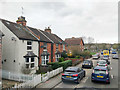
1
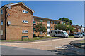
Brampton House and Scotney House
c.1960s housing in Petridge Road, off Heston Road in South Earlswood.
Image: © Ian Capper
Taken: 16 Jun 2021
0.00 miles
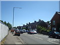
2
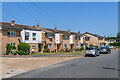
Heston Road
c.1970s housing in South Earlswood.
Image: © Ian Capper
Taken: 16 Jun 2021
0.04 miles
3
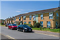
Heston Road
c.1970s housing in South Earlswood.
Image: © Ian Capper
Taken: 16 Jun 2021
0.05 miles
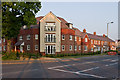
4
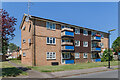
Barnard House
c.1960s housing in Heston Road in South Earlswood.
Image: © Ian Capper
Taken: 16 Jun 2021
0.07 miles
7
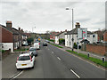
A23 Horley Road, South Earlswood
Heading north towards Redhill.
Image: © Robin Webster
Taken: 23 Mar 2019
0.08 miles
8

Junction of Maple Road with A23 Horley Road
Allotments are on the corner plot.
Image: © Robin Webster
Taken: 23 Mar 2019
0.09 miles
9

Maple Road Allotments
Allotment gardens on the corner of Maple Road and Horley Road.
Image: © Ian Capper
Taken: 16 Jun 2021
0.09 miles
10
Warwick Gardens
New development on the site of the Causeway pub (see Image), at the junction of Three Arch Road with Horley Road.
Image: © Ian Capper
Taken: 9 Jul 2013
0.09 miles