IMAGES TAKEN NEAR TO
Copper Close, BURGESS HILL, RH15 9XJ
Introduction
This page details the photographs taken nearby to Copper Close, RH15 9XJ by members of the Geograph project.
The Geograph project started in 2005 with the aim of publishing, organising and preserving representative images for every square kilometre of Great Britain, Ireland and the Isle of Man.

There are currently over 7.5m images from over14,400 individuals and you can help contribute to the project by visiting https://www.geograph.org.uk
Image Map (Loading...)


Getting Data...Please wait
Leaflet Map data © OpenStreetMap
Images are licensed for reuse under creativecommons.org/licenses/by-sa/2.0
Notes
- Clicking on the map will re-center to the selected point.
- The higher the marker number, the further away the image location is from the centre of the postcode.
Image Listing (38 Images Found)
Images are licensed for reuse under creativecommons.org/licenses/by-sa/2.0
Image
Details
Distance
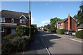
3
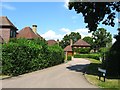
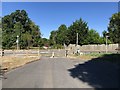
Barley Drive, Burgess Hill
Residential road linking Coulstock Road to Image and occupying a former field called Pear Tree Field according to Hurstpierpoint's 1842 tithe map, whose hedgerow trees remain in situ and whose shape can still be determined on aerial photographs.
Image: © Simon Carey
Taken: 25 Jul 2014
0.07 miles
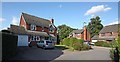
5
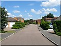
Seven Fields, Burgess Hill
The name of the cul de sac that runs off Malthouse Lane which was built during the 1990s. The estate is located within a former field called Upper Cow Pasture according to Hurstpierpoint's 1842 tithe map and the old shape of the field can still be made out by the trees that have been left standing in aerial photographs.
Image: © Simon Carey
Taken: 25 Jul 2014
0.09 miles
6
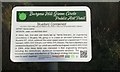
Bluebird Contained
The plaque on the Burgess Hill Green Circle Public Art Trail.
Image: © Chris Thomas-Atkin
Taken: 15 Dec 2017
0.10 miles
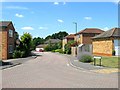
7
The Maltings, Burgess Hill
A cul de sac off Image that was built in the 1990s. Both roads lie within an old field called Pear Tree Field according to Hurstpierpoint's 1842 tithe whose outline can still be made out by the former hedgerow trees that were left standing.
Image: © Simon Carey
Taken: 25 Jul 2014
0.10 miles
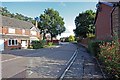
8
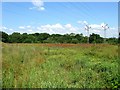
Five Acres
The name of the field according to Hurstpierpoint's 1842 tithe map that is now part of Burgess Hill Green Circle, a number of open spaces dotted around the outskirts of the town that allows public access. There is a surfaced path out of shot to the left that heads north to Image
Image: © Simon Carey
Taken: 25 Jul 2014
0.10 miles
9
Approaching Jane Murray Way
Gatehouse Lane is split by Jane Murray Way. The lane had previously been a major route out of Burgess Hill.
Image: © Chris Thomas-Atkin
Taken: 5 Aug 2018
0.10 miles
10
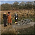
Public Art Trail Bluebird Contained
One of the five Sculptures on the Burgess Hill Green Circle Public Art Trail. This is 'Bluebird Contained' which commemorates the lives of Engineers: Eric Arthur (1912-1998), Kenneth William (1921-2005) & Lewis Hunt Norris (1924-2009). The Sculpture is situated at Grassmere Meadow.
In 1952, Eric, Ken, and Lew set up ‘Norris Brothers’, an engineering consultancy in Burgess Hill and Donald Campbell approached them to design a boat to attempt the water speed record.
The brothers created an all-metal hydroplane which became Bluebird K7 which achieved the water-speed record an unparalleled seven times for Britain between 1955 (202.32mph) and 1964 (276.33mph) before Campbell died at close to 300mph on Coniston Water in 1967.
See Image
The Sculpture was unveiled on 15th December 2017 in the presence of family members.
Image: © Chris Thomas-Atkin
Taken: 15 Dec 2017
0.11 miles