IMAGES TAKEN NEAR TO
St. Johns Avenue, BURGESS HILL, RH15 8HH
Introduction
This page details the photographs taken nearby to St. Johns Avenue, RH15 8HH by members of the Geograph project.
The Geograph project started in 2005 with the aim of publishing, organising and preserving representative images for every square kilometre of Great Britain, Ireland and the Isle of Man.

There are currently over 7.5m images from over14,400 individuals and you can help contribute to the project by visiting https://www.geograph.org.uk
Image Map
Images are licensed for reuse under creativecommons.org/licenses/by-sa/2.0
Notes
- Clicking on the map will re-center to the selected point.
- The higher the marker number, the further away the image location is from the centre of the postcode.
Image Listing (16 Images Found)
Images are licensed for reuse under creativecommons.org/licenses/by-sa/2.0
Image
Details
Distance

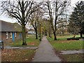
3
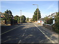
Junction of Newport Road with London Road, Burgess Hill
London Road is the B2036. The road opposite, making an offset crossroads, is Park Road.
Image: © Ruth Sharville
Taken: 28 Sep 2023
0.14 miles
5
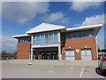
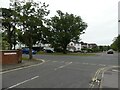
Sidney West Centre, Burgess Hill
Home to a variety of NHS services including Primary Care and Podiatry.
Image: © Richard Rogerson
Taken: 16 Apr 2018
0.15 miles
6
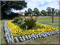
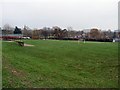
St John's Park, Burgess Hill
St John's Park is just off London Road, near the centre of Burgess Hill.
Image: © Marathon
Taken: 1 Aug 2015
0.15 miles
7
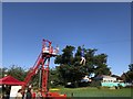
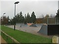
Zipwire in the park
A zipwire in St John’s Park.
Image: © Chris Thomas-Atkin
Taken: 25 Aug 2018
0.15 miles