IMAGES TAKEN NEAR TO
Folders Grange, BURGESS HILL, RH15 0SB
Introduction
This page details the photographs taken nearby to Folders Grange, RH15 0SB by members of the Geograph project.
The Geograph project started in 2005 with the aim of publishing, organising and preserving representative images for every square kilometre of Great Britain, Ireland and the Isle of Man.

There are currently over 7.5m images from over14,400 individuals and you can help contribute to the project by visiting https://www.geograph.org.uk
Image Map
Images are licensed for reuse under creativecommons.org/licenses/by-sa/2.0
Notes
- Clicking on the map will re-center to the selected point.
- The higher the marker number, the further away the image location is from the centre of the postcode.
Image Listing (5 Images Found)
Images are licensed for reuse under creativecommons.org/licenses/by-sa/2.0
Image
Details
Distance
1
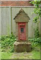
Old postbox on drive to Wintons Fishery
The notice in part reads "Delivery Point Wintons Farm Wintons Fishery Dove Cottage".
Image: © Shazz
Taken: 22 Jun 2016
0.04 miles
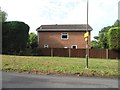
2
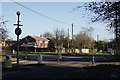
Burgess Hill
Junction of Kings Way with the B2113.
Image: © Peter Trimming
Taken: 10 Dec 2014
0.06 miles