IMAGES TAKEN NEAR TO
Birchwood Grove Road, BURGESS HILL, RH15 0DN
Introduction
This page details the photographs taken nearby to Birchwood Grove Road, RH15 0DN by members of the Geograph project.
The Geograph project started in 2005 with the aim of publishing, organising and preserving representative images for every square kilometre of Great Britain, Ireland and the Isle of Man.

There are currently over 7.5m images from over14,400 individuals and you can help contribute to the project by visiting https://www.geograph.org.uk
Image Map
Images are licensed for reuse under creativecommons.org/licenses/by-sa/2.0
Notes
- Clicking on the map will re-center to the selected point.
- The higher the marker number, the further away the image location is from the centre of the postcode.
Image Listing (5 Images Found)
Images are licensed for reuse under creativecommons.org/licenses/by-sa/2.0
Image
Details
Distance
1
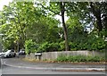
Folders Lane at the junction of Keymer Road
Image: © David Howard
Taken: 9 Aug 2018
0.09 miles
2
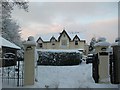
Wykeham, Birchwood Grove Road
Wykeham, a substantial residential property in Birchwood Grove Road, near to Birchwood Grove Primary School and Newick House School. Taken from end of driveway.
Image: © Curtis Bateman
Taken: 7 Jan 2010
0.14 miles
3
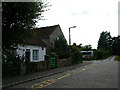
Birchwood Farm, Burgess Hill
Once a rural farm now a building stuck between two schools. In the background is the entrance to Newick House Special School whilst out of picture on the left hand side is Birchwood Grove Primary School.
Image: © Simon Carey
Taken: 24 Sep 2005
0.16 miles
4
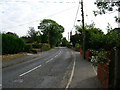
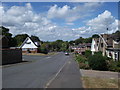
Keymer Road, Burgess Hill
Looking south as the road heads out of Burgess Hill.
Image: © Simon Carey
Taken: 24 Sep 2005
0.20 miles
5
Oak Hall Park at the junction with Beechwoods.
Late 20th century housing in the south of Burgess Hill.
Image: © Curtis Bateman
Taken: 22 Jul 2010
0.25 miles