IMAGES TAKEN NEAR TO
Barfields, REDHILL, RH1 4RD
Introduction
This page details the photographs taken nearby to Barfields, RH1 4RD by members of the Geograph project.
The Geograph project started in 2005 with the aim of publishing, organising and preserving representative images for every square kilometre of Great Britain, Ireland and the Isle of Man.

There are currently over 7.5m images from over14,400 individuals and you can help contribute to the project by visiting https://www.geograph.org.uk
Image Map
Images are licensed for reuse under creativecommons.org/licenses/by-sa/2.0
Notes
- Clicking on the map will re-center to the selected point.
- The higher the marker number, the further away the image location is from the centre of the postcode.
Image Listing (18 Images Found)
Images are licensed for reuse under creativecommons.org/licenses/by-sa/2.0
Image
Details
Distance
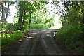
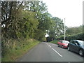
2
Tilgate Common, Bletchingley
A scrap of wooded common land largely surrounded by housing.
Image: © Robin Webster
Taken: 21 Jan 2011
0.05 miles
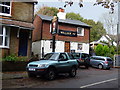
4
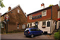
William IV
A pub has stood on this site since at least 1840.
Image: © Ian Capper
Taken: 9 May 2009
0.09 miles
5
William IV
A pub has stood on this site since at least 1840.
Image: © Ian Capper
Taken: 9 May 2009
0.09 miles
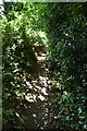
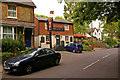
7
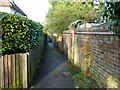
Footpath to Clare Cottages
Viewed from the Castle Street (A25) end.
Image: © Robin Webster
Taken: 21 Jan 2011
0.15 miles
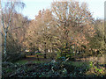
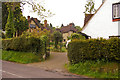
8
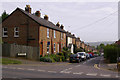
Barfields
19th century cottages on the outskirts of Bletchingley.
Image: © Ian Capper
Taken: 9 May 2009
0.16 miles