IMAGES TAKEN NEAR TO
Place Farm Road, REDHILL, RH1 4QR
Introduction
This page details the photographs taken nearby to Place Farm Road, RH1 4QR by members of the Geograph project.
The Geograph project started in 2005 with the aim of publishing, organising and preserving representative images for every square kilometre of Great Britain, Ireland and the Isle of Man.

There are currently over 7.5m images from over14,400 individuals and you can help contribute to the project by visiting https://www.geograph.org.uk
Image Map
Images are licensed for reuse under creativecommons.org/licenses/by-sa/2.0
Notes
- Clicking on the map will re-center to the selected point.
- The higher the marker number, the further away the image location is from the centre of the postcode.
Image Listing (24 Images Found)
Images are licensed for reuse under creativecommons.org/licenses/by-sa/2.0
Image
Details
Distance
2
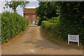
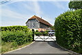
Place Farm
An 18th century farmhouse built out of the 16th century gatehouse of Bletchingley Place, a residence of Anne of Cleves, which was demolished in 1670. Grade II* listed - for listing particulars see www.historicengland.org.uk/listing/the-list/list-entry/1029989.
Image: © Ian Capper
Taken: 3 Jul 2010
0.02 miles
3

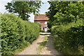
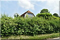
Place Farm Road by the entrance to Place Farm
The farm is behind the hedges on the right
Image: © David Howard
Taken: 29 Sep 2014
0.04 miles
4
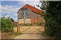
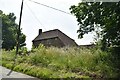
Place Farm Barn
A recent renovation/conversion of a grade II listed 17th century barn. For listing particulars see www.historicengland.org.uk/listing/the-list/list-entry/1029947.
Image: © Ian Capper
Taken: 3 Jul 2010
0.04 miles
10
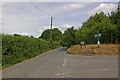
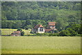
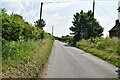
Junction of Place Farm Road with Whitehill Lane/Brewer Street
Place Farm Lane is off to the right, meeting Whitehill Lane/Brewer Street here (Whitehill Lane is ahead, Brewer Street behind). The blue sticker on the signpost indicates that Brewer Street/Place Farm Lane is part of National Cycle Network Route 21, from London to Eastbourne, this being the Woldingham to Redhill section.
Image: © Ian Capper
Taken: 3 Jul 2010
0.09 miles