IMAGES TAKEN NEAR TO
Cuckseys Lane, REDHILL, RH1 4NH
Introduction
This page details the photographs taken nearby to Cuckseys Lane, RH1 4NH by members of the Geograph project.
The Geograph project started in 2005 with the aim of publishing, organising and preserving representative images for every square kilometre of Great Britain, Ireland and the Isle of Man.

There are currently over 7.5m images from over14,400 individuals and you can help contribute to the project by visiting https://www.geograph.org.uk
Image Map
Images are licensed for reuse under creativecommons.org/licenses/by-sa/2.0
Notes
- Clicking on the map will re-center to the selected point.
- The higher the marker number, the further away the image location is from the centre of the postcode.
Image Listing (12 Images Found)
Images are licensed for reuse under creativecommons.org/licenses/by-sa/2.0
Image
Details
Distance
1
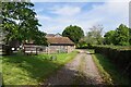
Cucksey's Farm
Located on Bletchingley Bridleway 180.
Image: © Glyn Baker
Taken: 27 Sep 2023
0.03 miles
2
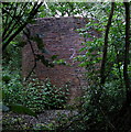
Air shaft of Bletchingley Tunnel
When the Bletchingley railway tunnel http://en.wikipedia.org/wiki/Redhill_to_Tonbridge_Line was made in the 1830s trains were steam powered and slow by today's standards. Although the tunnel is just over a kilometre long, eleven air shafts were provided to vent the smoke. This is Shaft No. 2. The tunnel can be seen in Image
Image: © Roger W Haworth
Taken: 24 May 2006
0.11 miles
3
Cinderhill Cottage seat
Located on Bletchingley Bridleway 180.
Image: © Glyn Baker
Taken: 27 Sep 2023
0.17 miles
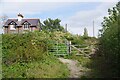
4
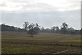
Path out of the wood
Branching south from the track used as a public bridleway, this private path into the field has not merited such a big gate for a long time.
Image: © Robin Webster
Taken: 25 Jan 2010
0.17 miles
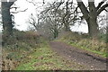
5
Gate by Cinderhill Cottage
On Bletchingley Bridleway 180.
Image: © Glyn Baker
Taken: 27 Sep 2023
0.19 miles
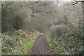
7
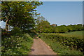
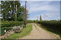
Track north of Cuckseys Farm
Track forming part of the bridleway from South Park to Outwood Lane.
Image: © Ian Capper
Taken: 25 Apr 2011
0.20 miles
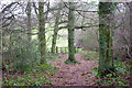
8

Bridleway through Tye Copse
The coppicing that gave this woodland its name is still evident.
Image: © Stephen Craven
Taken: 14 Oct 2012
0.22 miles