IMAGES TAKEN NEAR TO
Castle Close, REDHILL, RH1 4LG
Introduction
This page details the photographs taken nearby to Castle Close, RH1 4LG by members of the Geograph project.
The Geograph project started in 2005 with the aim of publishing, organising and preserving representative images for every square kilometre of Great Britain, Ireland and the Isle of Man.

There are currently over 7.5m images from over14,400 individuals and you can help contribute to the project by visiting https://www.geograph.org.uk
Image Map
Images are licensed for reuse under creativecommons.org/licenses/by-sa/2.0
Notes
- Clicking on the map will re-center to the selected point.
- The higher the marker number, the further away the image location is from the centre of the postcode.
Image Listing (204 Images Found)
Images are licensed for reuse under creativecommons.org/licenses/by-sa/2.0
Image
Details
Distance
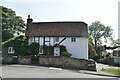
4
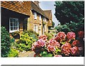
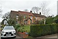
Church Street, Bletchingley
Typical old tile-hung Surrey cottages.
Image: © Colin Smith
Taken: 1 Aug 2002
0.03 miles
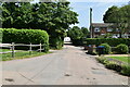
5
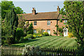
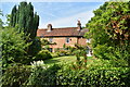
Laundry Cottage and Georgian Cottage
These two cottages in Castle Square (the former on the left, partly hidden by trees, the latter in the centre of the photo) are both 18th century and designated by Tandridge District Council as a building of character, their equivalent of local listing.
Image: © Ian Capper
Taken: 25 Apr 2011
0.03 miles