
IMAGES TAKEN NEAR TO
Bletchingley Road, REDHILL, RH1 4HW
Introduction
This page details the photographs taken nearby to Bletchingley Road, RH1 4HW by members of the Geograph project.
The Geograph project started in 2005 with the aim of publishing, organising and preserving representative images for every square kilometre of Great Britain, Ireland and the Isle of Man.

There are currently over 7.5m images from over14,400 individuals and you can help contribute to the project by visiting https://www.geograph.org.uk
Image Map
Images are licensed for reuse under creativecommons.org/licenses/by-sa/2.0
Notes
- Clicking on the map will re-center to the selected point.
- The higher the marker number, the further away the image location is from the centre of the postcode.
Image Listing (70 Images Found)
Images are licensed for reuse under creativecommons.org/licenses/by-sa/2.0
Image
Details
Distance
1
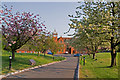
Robert Denholm House
A late Victorian mansion, originally known as Capenor, built in 1887 by James Hudson, of Hudson's Soaps. In 1890, he was High Sheriff of Surrey. It is now a conference centre and offices.
Seen here with spring blossom on the trees lining the drive.
Image: © Ian Capper
Taken: 21 Apr 2011
0.02 miles
2
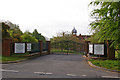
Robert Denholm House
A late Victorian mansion, originally known as Capenor, built in 1887 by James Hudson, of Hudson's Soaps. In 1890, he was High Sheriff of Surrey. It is now a conference centre and offices.
Image: © Ian Capper
Taken: 9 May 2009
0.06 miles
3
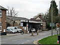
A25 Garage, Nutfield
It seems to be principally a car wash now.
Image: © Robin Webster
Taken: 23 Mar 2019
0.11 miles
4
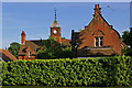
Hunters Mead and West Lodge
At the junction of Coopers Hill Road and Bletchingley Road, built in the 1880s as the stable block for Capenor, now Robert Denholm House (see Image). For close up of crest on West Lodge, see Image
Image: © Ian Capper
Taken: 16 Jun 2009
0.11 miles
5
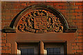
Crest on West Lodge
See Image The motto, Animo non Astutia (By Courage not by craft), is of the Clan Gordon - however I haven't been able to find any connection between this clan and this building.
Image: © Ian Capper
Taken: 16 Jun 2009
0.12 miles
6
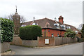
Capenor outbuildings, Nutfield
Now a residential conversion.
Image: © Robin Webster
Taken: 23 Mar 2019
0.12 miles
7
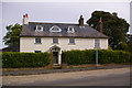
Halfway House
Grade II listed house originally dating from the late 17th century - for listing particulars see www.historicengland.org.uk/listing/the-list/list-entry/1029902.
Image: © Ian Capper
Taken: 9 May 2009
0.12 miles
8
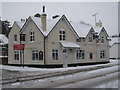
Crown Veterinary Clinic, Nutfield
On corner of High Street and Cooper's Hill Road. This building was formerly the Crown public house.http://sites.google.com/site/crownvetswebsite/
Image: © Rib
Taken: 1 Dec 2010
0.13 miles
9
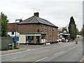
Corner shop, Nutfield Cross
Currently housing 'Period Flooring'.
Image: © Robin Webster
Taken: 23 Mar 2019
0.13 miles
10
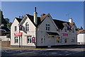
Former Crown Public House
A former pub, dating from around 1883. It now houses a vet's practice, which has retained the name by calling itself the Crown Veterinary Clinic.
For close up of the Greene King plaque by the front door, see Image
Image: © Ian Capper
Taken: 25 Sep 2010
0.13 miles