IMAGES TAKEN NEAR TO
Cormongers Lane, REDHILL, RH1 4GB
Introduction
This page details the photographs taken nearby to Cormongers Lane, RH1 4GB by members of the Geograph project.
The Geograph project started in 2005 with the aim of publishing, organising and preserving representative images for every square kilometre of Great Britain, Ireland and the Isle of Man.

There are currently over 7.5m images from over14,400 individuals and you can help contribute to the project by visiting https://www.geograph.org.uk
Image Map (Loading...)


Getting Data...Please wait
Leaflet Map data © OpenStreetMap
Images are licensed for reuse under creativecommons.org/licenses/by-sa/2.0
Notes
- Clicking on the map will re-center to the selected point.
- The higher the marker number, the further away the image location is from the centre of the postcode.
Image Listing (19 Images Found)
Images are licensed for reuse under creativecommons.org/licenses/by-sa/2.0
Image
Details
Distance
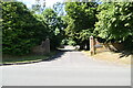
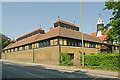
1
Patteson Court
Patteson Court was a large gothic-style house (see http://www.oldreigate.com/?goto=nutfieldroad ), built for a Mr Norman Wilkinson with building starting in 1847. Its final role was use by Laporte Industries as the headquarters of its Fullers Earth business, and it was demolished in the 1990s to enable an extension of the Fullers Earth site here, now being used for landfill. The name lives on in these offices, converted from the former stable block/outhouses.
Image: © Ian Capper
Taken: 25 Apr 2011
0.00 miles
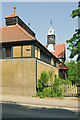
2
Patteson Court
Patteson Court was a large gothic-style house (see http://www.oldreigate.com/?goto=nutfieldroad ), built for a Mr Norman Wilkinson with building starting in 1847. Its final role was use by Laporte Industries as the headquarters of its Fullers Earth business, and it was demolished in the late 1990s to enable an extension of the Fullers Earth site here, now being used for landfill. The name lives on in these offices, converted from the former stable block/outhouses.
Image: © Ian Capper
Taken: 25 Apr 2011
0.00 miles
3
Patteson Court
Patteson Court was a large gothic-style house (see http://www.oldreigate.com/?goto=nutfieldroad ), built for a Mr Norman Wilkinson with building starting in 1847. Its final role was use by Laporte Industries as the headquarters of its Fullers Earth business, and it was demolished in the late 1990s to enable an extension of the Fullers Earth site here, now being used for landfill. The name lives on in these offices, converted from the former stable block/outhouses.
Image: © Ian Capper
Taken: 25 Apr 2011
0.00 miles
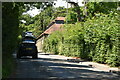
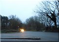
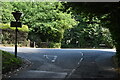
6
Fullers Wood Lane - Steep Hill 11%
Fullers Wood Lane, South Nutfield. 11% steep hill down sign, slightly overgrown.
Image: © Adam Morse
Taken: 6 Jul 2009
0.05 miles
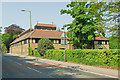
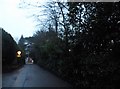
8
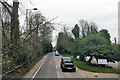
A25 Nutfield Road
Towards Nutfield, passing Nutfield Lodge, 'Conference and banqueting suite' on the right.
Image: © Robin Webster
Taken: 23 Mar 2019
0.06 miles